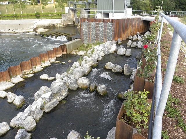
A space for water in the Common Agricultural Policy

River Great Ouse in arable farmland. © Copyright Hugh Venables and licensed for reuse under this Creative Commons Licence
A recent European report suggests that attempts to promote freshwater ecosystem conservation in European agricultural policy have so far proved largely unsuccessful. The report, published in May 2014 by the European Court of Auditors (pdf), describes how priorities for freshwater ecosystem conservation outlined in the Water Framework Directive (WFD) have yet to be successfully integrated into the Common Agricultural Policy (CAP).
The Common Agricultural Policy and the Water Framework Directive are two key European policies shaping the form and function of the continent’s environment. Formed in 2000, the WFD requires countries to achieve ‘good status‘ for surface and groundwater by 2015 through a set of River Basin Management Plans (RBMPs).
The ‘status’ of water is assessed using four measures: biological (e.g. biodiversity); hydromorphological (e.g. river bank structure); physical-chemical (e.g. temperature and nutrient levels); and chemical (e.g. water pollutants). According to a 2012 European Environment Agency report, it is ‘not likely’ that Europe’s water will reach the goals set out by the WFD in 2015, in either water quality (e.g. owing to pollution) or quantity (e.g. owing to abstraction).
Agriculture is a key source of environmental stress on freshwaters. In Europe, it accounts for around 33% of total water use (e.g. for irrigation) and is the main source of nutrient pollution in water. Agricultural land surrounds many lakes and rivers and significantly influences the quality and quantity of water that reaches them. As a result, there are increasing calls across the continent to devise ways that agriculture can become more ‘water friendly’.

Pond in farmland, West Sussex. © Copyright Glyn Baker and licensed for reuse under this Creative Commons Licence
Introduced in 1962, the Common Agricultural Policy is the main policy influence on Europe’s agricultural land. There have been repeated calls by the Council of the European Union to better protect freshwaters from agricultural water pollution and abstraction through CAP as a means of helping reach the water management goals of the WFD. This cross-policy process has been put into action through two policy instruments: cross-compliance and rural development.
Cross-compliance is a CAP mechanism which ties direct payments to farmers to compliance with a set of rules based on maintaining agricultural land in good environmental condition. Examples include reducing the use of sewage sludge on farmland, and promoting buffer strips of vegetation at the edge of rivers and lakes. Non-compliance with these rules can lead to reduced CAP payments to farmers.
Rural development is shorthand for the European Agricultural Fund for Rural Development (EAFRD), which provides financial incentives for farmers voluntarily going beyond the requirements of legislation to promote biodiversity conservation on their land. Such voluntary actions might include wetland restoration, reduced pesticide use, the ‘naturalisation’ of drains and ditches or more extensive grazing regimes.
The European Court Audit, carried out between 2012-13, involved visits to catchments in seven European countries, an online survey of 140 farm advisory boards, and consultation with agricultural organisations, EC departments and the European Environment Agency. It concluded that cross-compliance and rural development mechanisms have only been ‘partially successful’ in bringing the concerns of European water policy into CAP.

Riparian zone close to Lake Erie, USA. Image: Wikipedia
A key point here is that CAP has the potential to provide significant financial incentives to farmers to sustainably manage water through these mechanisms. CAP accounts for around 40% of the total EU budget (€58.1 billion in 2012) – a significant amount of funding, which if these mechanisms proved successful could significantly help strengthen the goals of the unfunded WFD.
So why have the European Court of Auditors concluded that cross-compliance and rural development mechanisms in CAP have only been ‘partially successful’ in promoting freshwater ecosystem conservation on agricultural land?
First, it is argued that delays in the implementation of the WFD in Europe have held up its integration into CAP. Second, cross-compliance mechanisms currently have key weaknesses in protecting freshwaters. Most importantly, they do not currently include regulations on the use of phosphorous (which can cause algal blooms) and pesticide use in assessing environmentally friendly farming, and there is only a partial implementation of the scheme at farm level.
Third, requirements for cross-compliance vary widely between European countries, particularly in the requirements for riparian buffer strips and use of water in irrigation. Fourth, the potential of the rural development fund to reward farmers for voluntary environmental conservation is underused with regards to water, with water-related problems relating to agriculture not comprehensively identified and integrated into the scheme.
Fifth, the ‘polluter pays‘ principle doesn’t exist in the CAP payment scheme, meaning that penalties for polluting, administered through reduced cross-compliance payments, may not equal the cost of cleaning up the polluted habitat. Sixth, it is argued that monitoring networks for the effect of agriculture on freshwater ecosystems across Europe are incomplete and fragmented, and therefore agri-environment evaluation schemes under CAP are of limited value.
In short, there are numerous ways that water-related problems in Europe could be better brought into existing mechanisms within CAP to help promote the goals of the WFD and work towards healthy freshwater ecosystems.

Brook and farmland, Gloucestershire. © Copyright Philip Halling and licensed for reuse under this Creative Commons Licence
The Audit therefore gives three key recommendations. First, the existing cross-compliance and rural development mechanisms should be altered to better promote sustainable water use (e.g. by incorporating phosphorous and pesticides into cross-compliance).
Second, it recommends that the process of implementing the WFD across Europe is speeded up for the next management cycle (which begins in 2015) to give clear, concrete goals for the CAP mechanisms to follow.
Third, it is suggested that monitoring systems for understanding and evaluating the links between agricultural practices and water quality and quantity are improved across Europe to help target areas where CAP funds are most needed.
Finding ways to make agriculture more ‘water friendly’ is a key challenge for freshwater conservation. We’ll publish more posts over the coming weeks on the theme, profiling schemes such as the collaborative ‘Water Friendly Farming‘ project in the UK, which looks to understand the effect of different agricultural practices on our freshwaters.
The designation and management of protected areas has been a cornerstone of biodiversity policy for more than a century. In the 1970s, for example, the international community agreed to expand the global protected reserve area system guided by the representation principle – the idea that populations of all species, as well as examples of all habitats, should be represented within regional and national protected area networks and reserve boundaries . They set a goal of 10% of the Earth’s land area to be protected, which has since increased to 17% under Aichi target 11.
Delivery of the representation principle has historically been constrained by gaps in biodiversity knowledge: for instance most reserve systems have been designed without reference to freshwater biodiversity simply because information on the distribution and status of freshwater biodiversity was unavailable.

Freshwater biodiversity and protected areas in Africa: a gap analysis (click on map to open Atlas)
Identifying the Key Freshwater Biodiversity Areas visualized on this map involved the production of distribution GIS shape files for every species of amphibian, fish, crab, dragonfly and freshwater plant in Africa. This hugely impressive undertaking of the IUCN Freshwater Biodiversity Unit was completed under the BioFresh project. The goal of KBAs is to improve place-based conservation of freshwater biodiversity. However it is the underlying KBA datasets as much as the mapped output that translates KBAs into action on-the-ground.
A good case in point is the Program to Reinforce the Protected Area Network (PARAP) in the Democratic Republic of the Congo (DRC). This is being implemented by the Institut Congolais pour la Conservation de la Nature (ICCN) and the World Wide Fund for Nature (WWF) and funded by the German Federal Ministry of Environment, Nature Conservation and Nuclear Safety (BMU) to support the DRC’s commitment to expand their reserve network to 17% of their national land a
According to Michele Thieme, Senior Freshwater Scientist with WWF the goal of PARAP was to revisit the DRC protected area system – “to go to existing protected areas and see what was still their and what threats they faced and then to redesign and expand reserve system. Part of this was to bring in the freshwater biodiversity dimension using MARXAN.”
MARXAN is a decision support software tool that deploys algorithms to generate reserve system design that achieve specified biodiversity representation goals in an optimal way. The MARXAN tool requires setting targets in the algorithms that process the habitat and species data. It then runs through multiple interactions and “spits out” the best solution and alternative scenarios based on the selection of different planning units.
Thieme started with a meeting of scientists and DRC government representatives with expertise in freshwater who set the conservation targets. These included the percentage of freshwater ecosystem types and species distribution to be represented in the reserve system along with the spatial scale of potential reserves. Next she described how they entered into the MARXAN software shape files of different ecosystems types that WWF had previously developed along with newly available IUCN KBA species distribution and similar data sets of freshwater mammal and bird distribution.
Needless to say running MARXAN for freshwater biodiversity was not quite so simple. Thiem describes how “the standard’ MARXAN algorithm is designed for terrestrial reserves systems and seeks to clump reserves where possible to promote connectivity. However hydrological connectivity is linear – along river systems.” To over-come this limitation she worked with Simon Linke and Virgilio Hermoso, Griffith University who adapted a piece of the MARXAN algorithm to take into account adjacent hydrosheds and clump hydrological regions thereby promoting hydrological connectivity.

The outcome of this freshwater biodiversity system design, along with full details of the methodology is available in the 2012 Technical report Technical Report “Preliminary Results of a Freshwater Biodiversity Marxan Analysis for the Democratic Republic of Congo”. The DRC government agency responsible for protected areas has the report but Thieme is not quite sure what currently is happening with it. It is not unusual that a scientific input seemingly disappears when entering the bureaucratic policy process only to reappear some indeterminate later is a tangible on the ground change. Lets hope this is the case for freshwater biodiversity and a revised DRC protected areas system design.
Maps in Action – the European Fish Index
In October 2000 the European Parliament adopted the Water Framework Directive (WFD), a land mark community framework to control pollution, promote sustainable water use, improve aquatic ecosystems and manage the effects of floods and droughts. The WFD requires member states to achieve “good status” for all waters by a set deadline and specifies two elements “good chemical status” and “good ecological status“.

Characterisation of fish sampling sites in Europe using EFI+ (click on map to open Atlas)
Annex V of the WFD defines what is meant by “good ecological status” and provides technical guidelines on how it should be interpreted and measured. It states that, for all types of freshwater member states should monitor and report on four biological elements, namely:
• Composition and abundance of aquatic flora (macrophytes and phytobenthos);
• Composition and abundance of benthic invertebrate fauna;
• Composition, abundance and age structure of fish fauna.
The EU comprises a set of institutions that assure European legislation has teeth. A key role of the European Commission (EC – the executive institution) is to monitor member state compliance with directives and to facilitate the development of monitoring tools and EC regulatory oversight.
Member states, particularly those with strong fisheries institutions, responded to the requirements of the WFD by developing their own national indices for assessing water bodies and their progress towards “good ecological status”. Lead developer of the European Fish Index (EFI), Didier Pont, notes that “this was not necessarily a bad thing. It created indices attuned to national conditions and institutions. The problem was that it made an EU-wide overview of progress difficult”. It also compromised the ability of the EC to identify member states that were falling behind and identify the areas where help – or prodding – would be beneficial.
This is where the European Fish Index comes in. It was developed in two steps – first as the Common Fish Index under the FAME project (2002-2005) and later as the EFI+ under a subsequent project. The map above, included in the Global Freshwater Biodiveristy Atlas, depicts the ecological status of 2,948 sites based on application of the EFI+.

Brown trout by T Knepp. Source Wikimedia Commons
Didier Pont recollects that the main challenge in creating a common assessment and reporting standard was defining and establishing common reference conditions in each river basin and type of water body. To develop the index it was necessary to identify and model ‘reference conditions’ with no or very low human pressure.
The EFI+ was part of a wider, and particularly complex effort, known as the ‘intercalibration exercise’. This sought to integrate member state indices of ecological status into five comparable status categories: high, good, moderate, poor and bad.
Indices, such as the EFI+ are what sociologist Andrew Barry terms ‘technological zones’, specifically zones of qualification (see Barry 2006). A technological zone is a space within which technical practices, procedures, and forms have been reduced. As well as being critical to the development of economy and society (e.g. infrastructural zones association with rail & telecommunication systems, and digital technologies) they are also critical for science to interface with policy at the supra-national scale.
Interestingly technological zones, such as the EFI+, have capacity beyond being simply a ‘connection standard’ for reporting. The EFI+ has been used as a template for the design of national fish indices by the Netherlands, Sweden and Romania and is likely to be picked up by countries outside the European Union. Indeed Didier Pont notes that there is interest in using the EFI+ to assess the success of restoration projects and/or for wetland offset projects.
In short, the EFI+ empowers the EC to assure compliance with the WFD but also acts to enroll a broader constituency of countries and sectors in the goals of improving the ecological status of freshwaters.

A pond in Swarzynice, Poland. Image: Mohylek, Wikipedia
One of the key outputs of the BioFresh project is an online portal which hosts databases on the biodiversity and function of freshwaters across Europe, which can be downloaded and used to help scientists, land managers and policy makers make informed decisions about freshwater conservation and restoration. BioFresh has recently published new datasets on the biodiversity of 460 European ponds, collected from scientific literature and unpublished sources.
Ponds are unique habitats, generally small, shallow, and highly interlinked with their surrounding environment, and can support a surprisingly large range of biodiversity. The Freshwater Habitats Trust suggests that over two-thirds of British freshwater species can be found in these often tiny habitats which pockmark gardens, parks, woodland and fields. Ponds provide pockets of habitat for a diverse range of freshwater species including dragonflies, frogs, newts and wetland birds, and can be created or reclaimed from marginal and degraded patches of land, such as in Million Ponds project.
However, ponds are not covered by the European Union’s main freshwater conservation policy The Water Framework Directive, and as such there are no strong regulations in place to protect and conserve them. As many ponds sit within urban and agricultural landscapes they are vulnerable to pollution. The Freshwater Habitats Trust suggest that over 50% of the UK’s ponds were filled in, drained or otherwise lost during the 20th century.
In response to these threats to unique pond ecosystems, The European Pond Conservation Network was set up in 2004 to promote the conservation of ponds and their biodiversity in Europe. The network, with members from European Universities and NGOs, has initiated new scientific research into the importance of pond habitats in supporting biodiversity and providing ecosystem services. The EPCN website explains in its ‘rationale‘ section that ponds not only provide important habitat for freshwater species, they also help connect different freshwater ecosystems as ecological ‘stepping stones’ across the landscape, and provide freshwater environments ‘close to home’ for people to experience, study and enjoy in urban areas – an important link between nature and culture.
For the pond database, BioFresh researchers collected data from a number of sources. Sebastian Birk describes the process: “we used peer-reviewed papers (e.g. those triggered by the European Pond Conservation Network) and grey literature (scientific reports) to provide species lists; various researchers provided their personal data collections (highly appreciated!); we were provided with the unique PLOCH (a method of sampling ponds) dataset that covered many ponds in Switzerland; and there was always a very supportive communication with the EPCN researchers.”
The BioFresh European Pond Database, which can be freely downloaded and shared, provides an important new resource for conservationists and policy makers seeking to understand the ecological importance and diversity of ponds across Europe. However, it is limited by differences in sampling techniques from data sources (e.g. there was no common measure of species abundance), and covers only a small percentage of the thousands of pond ecosystems across Europe. That said, it is an important and useful step in the right direction as part of a wider movement to help raise awareness of the importance of ponds, and conserve the wildlife that they support.
Some interesting links:
Tree of Rivers
Scientists from WWF have developed a new set of tools for planning ‘greener’ human development in the Amazon Basin in South America.
This new animation explains how WWF’s Hydrological Information System – Amazon River Assessment methodology (HIS / ARA) uses scientific data on how this vast rainforest and river system functions to asses if and how development (such as hydropower schemes) might take place along the 100,000 km of freshwater in the biome whilst minimising negative impacts on surrounding ecosystems.
The animation shows how the HIS / ARA project sees the Amazon as an integrated ‘vascular system’ of interconnected ecosystems. The project models ecosystem and hydrological data from the ecosystem scale all the way up to the whole Amazon basin in order to identify priority areas for conservation. This work is intended to show the most crucial freshwater ecosystems in the wider functioning of the Amazon basin, which are likely to be irrevocably degraded by human development, and so help strengthen their conservation and protection.

Location of barries in the Danube river basin
This map plots the location of barriers – mostly dams – that disrupt the migration and completion of life-cycles of fish in the Danube river system. It was developed to inform the development and implementation of the Danube River Basin Management Plan.
Located in central and eastern Europe the Danube is the world’s most international river basin: four countries – Romania, Hungary, Serbia and Austria – amount for over 50% of the river basin area, but 81 million people in 19 countries share the Danube River Basin.
The development of River Basin Management Plans is one of the key requirements of the EU Water Framework Directive. Prior to the introduction of the WFD in year 2000, the 1994 Danube River Protection Convention established already a legal framework for trans-boundary water management. To support implementation of this convention the International Commission for the Protection of the Danube River (ICPDR) was created and in year 2000 took on responsibility for coordinating implementation of provisions in the WFD. Given the size and the ecological, social, political and economic complexity of the Danube River Basin this is quite an undertaking!
The publication of the Danube River Basin Management Plan in 2009 was preceded by a range of assessments. Raimund Mair, a technical expert with ICPDR described how hydro-morphological changes to the river system, caused by dams and other structures, were a major issue for technical teams grappling with how to deliver the ‘good ecological status’ objective of the WFD. “The Danube supports a number of long- and mid-distance migratory fish that need to move along the river to their spawning grounds and are barred from doing so by dams”. The Sturgeon and Danube Salmon are the best known examples. Historically sturgeons travelled up to 2000 km from the Black Sea along the river system and have become something of a ‘poster child’ and ‘flagship species’ for the Danube.
Fish Ladder on the Danube. Source: http://pixabay.com/en/fish-ladder-munderkingen-danube-245601/
The purpose of the map of barriers is to identify priorities for investments in fish migration aids at points in the river system that will generate the biggest ecological gain. According to Mr Mair the number of dams is significant, requiring a decade or more to take the necessary measures to restore connectivity. According to the assessments the highest priority but also most outstanding challenge to establish continuity are the so-called ‘Iron Gate’ hydropower dams at the 134 km long Iron Gates Gorge linking Romania and Serbia.
Mr Mair explained how the process of creating the map establishes its conservation policy impact. The ICPDR convenes technical teams involving experts from river management and conservation agencies in the ICPDR member states. “The process of developing methodologies – for instance criteria for prioritising measures at dams – helps to build a shared understanding of the river system, its ecology and the challenges of management, creating the ability to have conservation policy impacts”. This ‘bigger picture’ knowledge in combination with the shared policy vision and agenda of an international technical team empowers national experts to translate the map into action in their respective countries, and to elaborate more detailed prioritisation agendas at national level respectively.

Prioritisation for restoration of barriers in the Danube river basin
A key task for implementation is to create understanding and support with the owners of the facilities as well as to mobilise the funds to construct the fish passes and other migration aids. These are not cheap, and different countries adopt financing models attuned to national circumstances and opportunities. “In some countries a major share of the funds come from government budgets, and often some form of co-financing arrangement is agreed between government and the company or institution owning and operating the dam. EU funds have also been applied for.” noted Mr Mair. The point here is that it is the combination of the map and supporting technical documents and an international technical committee that creates and legitimates the case for investment in structures that aid fish migration across structural barriers.
Additionally, this map communicates a clear vision to an environmental issue. Conservation NGOs, notably the WWF Danube Carpathians Programme, use their networks, policy access and public profile to convince governments and industry to implement prioritisation agendas for restoring ecological connectivity and mobility in the Danube river system.
In summary, this map in the Global Freshwater Biodiversity Atlas is far more than a 2-dimensional depiction of priority locations for the installation of fish migration aids. It embodies a transnational movement of technical experts working to restore the ecology of one of the world’s greatest river systems.
Dialogue, debate and new horizons for science blogs

Catalonian mountain stream. Image: Nuria Bonada
In Part One of their discussion, Paul Jepson and Rob St. John covered the practicalities and possibilities of running a science blog. In this second, and final instalment, they discuss the role of dialogue and debate in science communication through blogs, and sketch possibilities for future developments in the field.
—
Rob St. John: We’ve talked about different types of blog posts – features, interviews, multimedia content – I’m interested now in what happens when a blog post is published. PLOS science blogs published an article at the end of 2012 entitled ‘Ten Essential Qualities of Science Bloggers’ – which included qualities such as a distinct voice, enthusiasm and an awareness of audience which we’ve covered here. One of the qualities that interested me was ‘to engage in civilised debate’. In a lot of ways, I think this relates to the dialogue and engagement based models of science communication (a good Alice Bell blog on the topic here) that we used to help guide our approach for setting up the blog.
I’ve two questions on this: first, how successful has the blog been in facilitating debate? Second, how does the blog as a focus for debate help us form the communities and networks that you mentioned right at the start of the interview?
Paul Jepson: Given my experience with BioFresh I feel that facilitating on-line debates is one of the real challenges for science blogs – they’re time consuming and require expertise and tact to facilitate and moderate. Discussion flowed when we re-posted Martin Sharman’s 2013 post on ecosystem services on a freshwater related LinkedIn group, which brought a new community into the debate. As we know the blogosphere can be open to some pretty sharp and opinionated comment, which you have to be either think-skinned or experienced (or both) to with.
At the moment my thinking is that science blogs such as ours work well in the sense of traditional media – providing a collection of stories, perspectives, reports and responses that may be discussed in the analogue world – chatting over coffee, on the phone, at meetings – and this is when they help strengthen epistemic communities and networks.
RSJ: So the blog is one node in a set of information, which stimulates debate and information exchange both online (LinkedIn, Twitter etc) and in real life?
PJ: I see them as sitting among a scientific assembly of journals, conferences, workshops, project meetings and so forth. But they offer something new – the ability to connect, provide regular reminders of community and shared interest, and to engage the wider scientific, cultural and recreational interests public audiences in the field..

Screenshot from ‘Water Lives…’ animation (2012)
RSJ: Following on from Martin Sharman’s much discussed post on ecosystem services, I wanted to ask whether you think that a story needs to be controversial in order to find an audience? Can important, but non-headline grabbing stories bring people to the blog and stimulate debate?
PJ: I don’t think a post has to be controversial to be engaging, no. And absolutely, I think there is a public information role for blogs in communicating the stories that don’t grab the headlines elsewhere. One of the pieces that you commissioned about the mayfly’s life cycle (by the Riverflies Partnership scientist Craig Macadam) is our most popular post ever – and I think will continue to be so – because it provides a great answer to a commonly asked search engine query: ‘What is a mayfly?’ and now tops the Google result for that questions.

Leafpack in the Cuisance River (France) Image: Núria Bonada
RSJ: So search engine optimisation is useful in bringing people to the blog. The post has also been listed as an authoritative source on the Wikipedia page for the mayfly.
PJ: I think the potential of building on these posts as interactive information resources on other social platforms is something we haven’t fully explored yet. For instance, the post by Szabolcs Lengyel on wrapping bridges for may fly conservation was eye-opening and fantastic, and these sort of posts could be linked to places on Google Earth and even Google Glass in such a way that when somebody is on the bridge (in this case of the Tisza) or sees the phenomenon in real life, these engaging scientific accounts might pop up.
RSJ: I wanted to bring a set of different people together with the mayfly series to create a set of posts with wide appeal, which I think was pretty successful. On your last point about extending the blog with new technologies, the platforms we use such WordPress do set limits on what we can currently create in terms of interactivity without engaging with programmers. I wanted to ask you what you thought about what’s on the horizon for future blogging and science communication projects?
PJ: In think you a right. In a sense we’ve been exploring the new frontiers of science communication but that frontier is only just opening up with new technology. As the potential of natural language data processing and predictive analytics becomes more widely known I think we are going to see much more integration of blogs and other on-line platforms. The Guardian data blog is interesting to follow in providing pointers, not only for the sort of material that science blogs are likely to carry, but maybe in predicting the fusion of data, narrative and reader preference in the future.
For me, working on the BioFresh blog since 2010 has helped me scope future possibilities and purposes of science communication. I am not entirely sure where things are going, but I am much more aware of what to track and read, who to network with and what to respond to, as a result.

Lilla Fargen, Sweden. Image: Wikipedia
RSJ: I think for me, one of the overarching benefits or values of the blog has been what Sarah Tomlin called ‘an insight into the academic coffee room chatter that the public is not usually privy to’. I like the potential of the blog in profiling and discussing journal articles, research threads, even large EU projects that otherwise go unnoticed.
PJ: In many ways is also all about accountability. Transparency in different forms is become more and more important in maintaining the legitimacy of science in society, and I think science communication work through blogs helps shed light on aspects of big research projects that might otherwise be missed by the public. And now the BioFresh blog is transitioning to the MARS project and the Freshwater Blog. It’s a real strength of these science blogs that they can be passed on and maintained as one project finishes and another one starts. They are a transferable ‘asset’ for science, policy and, I hope, society.
Why run a science blog?

A beautiful photograph of Lake Vendel, Sweden by BioFresh scientist Sonia Stendera
In the coming weeks, this blog will transition to the new Freshwater Blog run by the MARS project. To mark this transition, Paul Jepson and Rob St. John discussed the process of running the BioFresh blog, broadly asking: ‘what is the value of running a science blog?‘.
Paul is the head of the Biodiversity, Conservation and Management MSc course at Oxford University and the leader of the Communication and Dissemination work package with BioFresh. Rob is an environmental writer, and will run the new Freshwater Blog. Paul and Rob set up and edited the BioFresh blog in 2010.
This discussion is split into two parts. Part two will be published on Monday.
—
Rob St. John: I think we should open with a broad question: what’s the value of running a science blog like this one?
Paul Jepson: There’s two answers to this. First, the value for the wider science and policy community and our intended audiences; and second, the value for the people running the blog – the editor and author(s).
On the first point, I think that the BioFresh blog shows the potential of science blogs in strengthening and giving profile to epistemic communities – by which I mean the communities of scientists who help decision-makers to define the problems they face and deliver the policy frameworks for which they are responsible. In our case this community was freshwater scientists and policy-makers delivering the EU biodiversity strategy and directives such as the Water Framework Directive.
On the second point, the value for me was developing my understanding of the practicalities of running a blog, from developing editorial guidelines to translating science and policy into short easy to read pieces which integrate with wider social media ecosystems.
Reflections on water in Europe. Image: Europa JRC
RSJ: I guess there’s also a third main value – that of reaching new, interested audiences with science and policy issues that might not otherwise reach them. When thinking about how the blog is run, one common response from academic and policy making colleagues is that the process of blog writing and commenting is too time-consuming to be practical, and has little benefit for the researcher. Do you think this is the case?
PJ: I’d agree with the time-consuming nature of commenting on posts. We do need to formulate comments carefully because we are operating in an environment where precision and evidence are considered a key quality of a scientist’s work, and the fast paced nature of comment threads may seem a world away from this.
However, the writing side is easier for two reasons. One is that it can be fun and relaxing to write about your work in a popular style and I find this can free me up to think about things in fresh ways. Similarly, as leader of the Biodiversity, Conservation and Management MSc course at Oxford University, I have found that science blogs give students an opportunity to gain experience and skills in science communication and public engagement.
RSJ: Would you agree that developing skills in communication and engagement is an important outcome for modern conservation courses like BCM?
PJ: Yes I do. There seem to be more and more jobs opening up in think tanks and consultancies, and as science-policy advisors and all of these roles need good public engagement skills. I think the style used for writing and then promoting blog posts via social media (for example, Twitter) helps develop skills many employers are increasingly looking for.
RSJ: One of the main values of the blog is as a node on a network of different people loosely connected with freshwater research, conservation and policy. This network also includes wider interest groups: fishermen, aquarium keepers, wild swimmers and the general public.
The blog becomes a place where all sorts of information can be pulled together and put across in a clear, engaging way. I think ideally, it brings different people together to find out and celebrate the value of freshwaters. Based on what we’ve talked about so far, I’m interested in finding out whether your involvement in the blog has influenced your professional practice in any way?

Paul Jepson and Klement Tockner in discussion
PJ: I’m not sure about that. There’s the idea here of working as a boundary scholar across disciplines, which might sound a bit pretentious, but for me blogs embody the idea that there’s no such thing as lone science anymore. But generally I’m seeing that the ecological sciences are needing to embrace technologies and expertise from other disciplines – information engineering, computer science, linguistics, anthropology, social science and so on.
One of the benefits of the blog is that it fits with the idea that new frontiers for science and policy lie in forms of collaboration and interdisciplinarity: blogs creates a virtual space where different groups can share ideas and get a sense of where each other are coming from to work towards common goals.

Screenshot from ‘Water Lives…’ animation (2012)
RSJ: Let’s talk about the practicalities of putting a blog post together. For example, a blog post explaining and analysing a new journal article will usually take me around one or two working days to research, write, edit and fact check before it can be published. It can be done more quickly, but I’m very aware of making sure every piece is accurate and fact checked before publication.
It’s really a case of making sure you can pull out the important messages from a piece of research and then translating these into forms that your audience will be receptive to. How do you manage that process of finding stories to report, then translating them into blog posts?
PJ: You’re right on the science reporting. I think when you and I were running the blog (between 2010-2012), we had a good system of planning a mix of different types of posts, which required different levels of precision and therefore amounts of time to write. For example, I liked doing the interviews with policy makers and scientists. The one with Anne Teller probably took less than 3 hours in total time to complete. All it took was a couple of emails to get Anne on board, then generating a list of questions, tidying up her replies and formatting the piece for publication.
Video interviews are also very quick to do. Again, it’s just a matter of generating a few good questions, and then chatting these through for 10 mins and recording a short Skype video, and then maybe 45 minutes editing the video and writing the accompanying text. The production values of these videos are a bit DIY, but they get the ideas across concisely and engagingly without needing a huge amount of resources.
RSJ: That’s a related question: do you need a lot of resources to put together multimedia material for a science blog?
PJ: No, this is the beauty of computing as a utility. I think all we used was WordPress platform, Skype and some paid add ons for each.
RSJ: So it’s possible to create a range of interesting multimedia with a basic set of computer resources that most academics, students or policy makers will already have available to them such as webcams, coupled with cheap and free software and platforms like WordPress (for creating blogs), Audacity (for editing audio) and Soundcloud (for uploading it), iMovie (for editing video) and Vimeo and YouTube (for uploading it).
In addition to the daily and weekly features and interviews, we put together a few more ambitious projects with high production values such as Water Lives… animation, the BioFresh animation and the Final Symposium video and podcast. What’s the value of more ambitious, often interdisciplinary projects like these?
PJ: A collaborative project such as ‘Water Lives…’ got us and the blog featured on other big blogs such as National Geographic and their social media feeds. Basically, they provided an opportunity to increase reach and readership beyond our ‘normal’ audience networks. I think Will Bibby (blog writer 2012-13) saw another potential, in that these video projects can be re-used over and again in the context of the numerous online events such as World Water Day.

Scientists make excellent photographers! A river in the Rif region (Morocco) by BioFresh scientist Núria Bonada
RSJ: So these more ambitious science communication video projects related to the blog have two important features. First, they have the ability to travel and be picked up by media and audiences that we wouldn’t otherwise reach; and second, they have a longer lifespan and remain relevant and can be used for a variety of other communication initiatives (not least in teaching, conferences, workshops etc) as well as online.
I’d add a third key value, in their creative potential for everyone involved: scientists and policy makers alongside artists and writers. This loops back to what you said at the start of this interview about the blog as a place where people can find fresh expressions of their work outside of the limits of academic writing and presentations. They give an opportunity for everyone to engage with the same material – microscopic diatoms, in the case of ‘Water Lives…’ – in new, creative ways. In terms of engaging audiences with science, I can only see this as a positive thing.
PJ: This chimes with our ongoing discussions about the role of artistic engagements in the generation of novel approaches to research and action in conservation – or any field of academic and policy endeavour (see for example, our artist statements for the Water Lives… project)
—
Part Two will be published on Monday, reflecting on what happens when a blog post is published, how to facilitate and moderate debate, and thinking about new developments in science communication.
Maps in Action: Freshwater Ecoregions of the World
A fundamental task of conservation science is to create planning frameworks that simultaneously render important attributes of nature visible, create the imperative for strategic action, and support the implementation of conservation policy instruments. This map from the Global Freshwater Biodiversity Atlas exemplifies one way this task is realised in practice.

In response to the 1992 Convention on Biological Diversity substantial funds were committed to the conservation of biodiversity internationally. Two of the world’s leading conservation Non-Governmental Organisations (NGOs), the World Wildlife Fund (WWF) and The Nature Conservancy (TNC) joined forces to create a global ecoregional planning framework. This set broad scale spatial priorities to guide the field programmes of their organisations as well as others, and to support biodiversity conservation investment decisions by international donors. There are now three dedicated ecoregion ‘maps’: covering terrestrial (2001), marine (2007) and freshwater (2008). Together these maps present regional scale ecosystems at a global level.
The Freshwater Ecoregions of the World (FEOW) map took 10 years to complete and involved coordinating contributions of over 100 scientists worldwide. Co-lead Robin Abell described how its production involved overcoming the challenge of poor species data in regions such as Southeast Asia and much of Africa, pushing taxonomic experts to make their best estimations of where they would expect to find different species and species groups. According to Ms. Abell, “one of the key conceptual challenges was how to align biogeographic patterns of freshwater biodiversity with river basins. River basins are the key unit of freshwater ecosystem policy and management.” Whilst basin topography is a critical factor influencing the patterns of freshwater species distributions, it is not the only one. In many cases it was not possible to align biography and basin (geo-morphology) and biographical consideration took precedent. The down side of emphasizing biogeography is that the species lists compiled for each ecoregion are sometimes not of direct use to managers focused on a particular river basin. The up-side is that it brings freshwater datasets into the sub-discipline of conservation biogeography – the application of biogeographical principles, theories, and analyses, being those concerned with the distributional dynamics of taxa individually and collectively, to problems concerning the conservation of biodiversity.
None-the-less, in 2006 Brazil incorporated freshwater ecoregions as planning units into their National Water Resources Plan – the first such plan for any South American country. This assures that aquatic biodiversity management becomes a strategic consideration for water resource management alongside traditional priorities of hydro-power, navigation, irrigation drinking water and sanitation.

Confluence of the Iguazu and Parana rivers. On the left is Paraguay, on the right Brazil, taken from Argentina Phillip Capper, Wikimedia Commons
Commenting at the time Glauco Freitas, the Nature Conservancy’s Great River Partnership (GRP) manager for the Paraguay-Paraná watershed, described how “from the beginning of our conversations with the Brazilian government about their freshwater management plan, they have been cognizant of the importance of protecting Brazil’s waters not only for the sake of their extraordinary aquatic life, but also to protect sources of water for communities. GRP actions will now be closely linked with the Freshwater Management Plan.” However, in the view of Ms. Abell the real policy impact of the Freshwater Ecoregions map is more fundamental. She describes how “15-20 years ago many in the conservation community weren’t talking about freshwaters. The discussions were either about terrestrial or marine, or about the biodiversity of regions such as Amazonia. The freshwater ecoregion project, along with that of other groups such as the IUCN Freshwater Unit, opened conversations about freshwater biodiversity and its conservation.” These had the effect of “drawing attention to freshwater as a domain of conservation in its own right”. In short, freshwater ecoregions are contributing to a shift in how we frame global biodiversity at the most basic level – from terrestrial & marine, to terrestrial, freshwater & marine.
Special Feature: Maps in Action
 Integrating the conservation and management of aquatic organisms into water resource policy is a major challenge. To support policy makers in this effort, freshwater scientists launched the online Global Freshwater Biodiversity Atlas in January 2014.
The Atlas currently contains about 30 maps organised into four chapters: freshwater biodiversity, resources and ecosystems, pressures, and conservation & management. It is a dynamic resource that will constantly be up-dated with new maps.
The term ‘atlas’ often evokes a collection of maps designed to foster discovery and learning on a particular topic. However, maps have always been more than representations. Many are also powerful decision support tools. Increasingly, the maps we see are spatial representations of geo-located data sets or assemblies of data sets, and for scientists and policy makers they draw attention to the availability of data that can be put to use.
This short series of articles aims to explore the active role of maps at the interface of science and policy.
- Freshwater Ecoregions
- Situation and prioritisation of barriers along the Danube and its tributaries for restoration of longitudinal connectivity
- The European Fish Index
- Key Freshwater Biodiversity Areas and protected area planning
Together these Maps in Action articles remind us that maps are a form of standard that enables coordinated action between nations and across scale. They foreground the role of maps in issue framing, the building of policy communities and shared understandings across scales, for prioritising policy implementation and legitimating the case for investments in actions to conserve, manage and restore hydrological systems.
The Global Freshwater Biodiversity Atlas is a major achievement of the BioFresh project because it brings together a unique overview of the status of interactions between freshwater biodiversity science and policy.


