A new atlas of European caddisflies

Chaetopteryx rugulosa has a small distribution area in the Eastern Alps, and is split into several subspecies. Image: © Graf & Schmidt-Kloiber
A major new European atlas of the distribution of caddisfly species (or Trichoptera) has recently been published, providing the first comprehensive overview of their occurrence patterns across the continent. Based on data collected over 7 years from over 630,000 species occurrence records, the Distribution Atlas of European Trichoptera features 1,579 maps of a fascinating, diverse and ecologically-important insect order.
Whilst freshwater ecosystems are known to support a rich diversity of species – there are more than 14,500 caddisfly species, of which more than 1,700 occur in Europe – their distribution maps are often patchy and incomplete. Comprehensive species mapping – as carried out here by the Atlas team – is important in guiding future scientific research and environmental policy and management.
Atlas co-author Astrid Schmidt-Kloiber says, “The Atlas shows us the distribution ranges of every single caddisfly species in Europe, it reveals common species as well as rare ones and identifies Trichoptera hot spots. With the help of fellow caddisfly experts we compiled occurrence records from all over Europe into one single database, which now serves as a valuable base to establish a European IUCN Red List of threatened species.”

Limnephilus subcentralis – as many other Limnephilidae species – covers a huge range from Scandinavia to the Balkans and from Belarus to UK. Image: © Graf & Schmidt-Kloiber
The idea for the Atlas was first discussed in 2005 at the ‘First Conference on Faunistics and Zoogeography of European Trichoptera’ in Luxembourg. The Atlas project was kick-started in 2011 as part of the EU-funded BioFresh project, and includes data contributions from 83 Trichoptera experts (see this open-access Hydrobiologica article for more detail).
Co-author Wolfram Graf explains, “The Atlas is a milestone in Trichoptera research: up to now species distribution ranges were only indicated on country level – such as Fauna Europaea – or on an ecoregional level – such as through the freshwaterecology.info portal. For the Atlas we collected point records. This, for the first time, reveals the real distribution range of a species. The Atlas serves to delimitate diversity spots and refuge areas for endemic species on different scales and is therefore an essential basis for any conservation issue.”
The Atlas shows that areas of southern Europe – particularly in Spain, Italy and the Balkans – and mountainous regions (such as the Alps and the Carpathians) support both high caddisfly biodiversity and endemism. In other words, these areas harbour a high biodiversity and support certain rare species which are not found anywhere else.

Species of the family Limnephilidae are found all over Europe, but several genera have very limited distributions. Image: Distribution Atlas of European Trichoptera
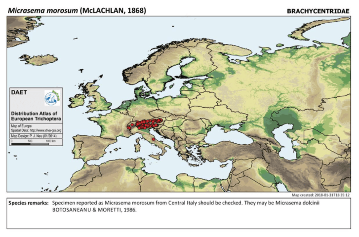
Micrasema morosum is a caddisfly species predominantly found in the Alps. Image: Distribution Atlas of European Trichoptera
In general, overall caddisfly species diversity decreases with increasing latitude. There is a similar drop in species diversity in the move from Western Europe to Eastern Europe, largely because caddisfly-rich mountainous areas are lacking on the eastern plains of the continent. In several cases, distinctive Atlantic and Siberian species – which underwent speciation processes in glacial ‘refugia’ in the last ice age – overlap in areas of Central Europe. These climate-induced speciation processes in ice-free parts of the content account for the increased present-day species diversity in Southern Europe.
Areas rich in caddisfly biodiversity and endemism such as the Mediterranean are particularly threatened by the ongoing effects of climate change and other anthropogenic pressures. The Atlas identifies these areas of conservation importance, which can subsequently help raise their visibility as an issue amongst environmental policy makers in Europe.

Leptocerus interruptus is a delicate species with a wide distribution throughout Europe. Image: © Graf & Schmidt-Kloiber
Co-author Peter Neu outlines the value of the Atlas, “By delineating the distribution areas, the Atlas provides invaluable help in identifying species that are difficult to distinguish and therefore also serves as a quality control tool for all future identifications, for example, for people who identify specimens from regions whose fauna is not familiar to them, the Atlas is a great decision aid. Through the Atlas, we can further identify species for which there is still a research need.”
Wolfram Graf continues, “The Atlas enhances our knowledge on evolutionary theories as well as on zoo- and phylogeographic aspects. The depicted maps are just the beautiful surface but the basic data are the true treasure which will be analysed in-depth now. The Atlas may be an inspiration for us and others to continuously collect faunistic data in order to be able to analyse long-term developments of this fascinating insect order in a changing world.”
Astrid Schmidt-Kloiber concludes, “As the success of the Atlas very much relied on the willingness of our colleagues to contribute data, I want to take the opportunity to thank them once again for their enthusiasm and great work!”
The Distribution Atlas of European Trichoptera is published by Conch Books

Image: Jim Liestman | Flickr Creative Commons
The Water Framework Directive (WFD) is the foundation of European Union water policy. Adopted in 2000, the WFD provides a policy framework for European member states to monitor, assess and manage their aquatic ecosystems. However, despite widespread improvements in the monitoring, conservation and restoration of rivers and lakes across Europe, the WFD has not yet achieved its primary objective: the good ecological status of all European freshwaters.
Part of the rationale for the MARS project’s work over the last four years has been to assess the success of the WFD in addressing contemporary issues for European water management. When the WFD was designed and developed in the 1990s, the issues facing Europe’s rivers and lakes were somewhat different to today. Strong single stressors such as nutrient pollution and water abstraction were common across the continent. In the time since, the challenge of multiple stressors – where stressors act in tandem, causing complex interactions and ecological impacts – has emerged.
Similarly, new challenges such as the pollution of microplastics and synthetic chemicals into water bodies means that water managers need to stay alert to the possible impacts of emerging stressors. However, new water body monitoring techniques for both ecological health and stress – such as those used for dissolved chemical ‘cocktails’ in the SOLUTIONS project – are being developed, providing new opportunities for effective water management.

Microplastics. Image: Florida Sea Grant | Flickr Creative Commons
A formal EU ‘fitness check’ evaluation of the WFD in the context of these developments is due in Autumn 2019. Ahead of this assessment, MARS researchers have published a policy brief providing recommendations for the future implementation and evaluation of European water policy. They identify four key areas to be addressed:
Monitoring and assessment systems
The researchers argue that whilst the WFD has significantly advanced the environmental monitoring and assessment of European water bodies, there are a number of problems with the current approach. They suggest that the strategic design of monitoring networks can be improved across the continent, and that monitoring the ecological effects of restoration management can be enhanced, for example, by using ‘early responding indicator’ species and metrics.
They highlight the concern that the WFD assessment uses overly strict criteria to define success, in which the overall ecological status of a water body is determined by the lowest of its biological, physical and chemical quality elements – potentially obscuring a more nuanced picture of the ecosystem. Finally, they outline the value of incorporating new monitoring tools such as earth observation, genomics, automated monitoring platforms and citizen science into WFD assessment, where appropriate.
Management measures
River Basin Management Plans (RBMPs) are a key WFD management tool. They are based on ecosystem monitoring data and outline management plans for entire river basins, addressing not only water bodies but also the drivers of environmental stress such as agriculture, hydropower and flood protection. In their policy brief, MARS researchers suggest that RBMPs can be improved through more targeted planning and implementation of measures to manage the emerging impacts from multiple stressors across Europe.
They highlight the availability of data and diagnostic tools to identify stressors and their interactions (such as those developed by MARS), which can help design effective and cost-effective management measures. They outline the value of trait-based diagnostic tools which can help diagnose the mechanisms behind environmental degradation; and of ecosystem service indicators which can provide powerful messages to the public and policy makers about the benefits of freshwater conservation and restoration.
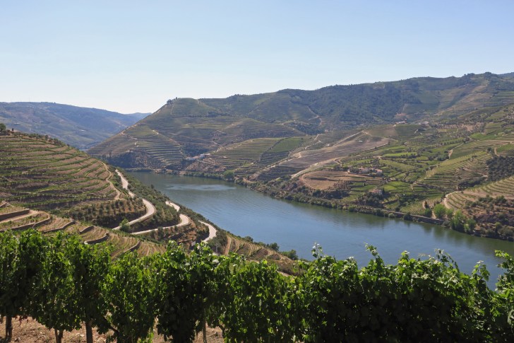
Agricultural terraces in the Douro River Basin, Portugal. Image: Malcolm Payne | Flickr Creative Commons
Policy integration
The MARS researchers argue that there is a need to harmonise and integrate the objectives and management of the WFD with other key European policy frameworks. One key policy relationship is with the Common Agricultural Policy (CAP). Diffuse pollution and habitat degradation as a result of agricultural activity are common pressures across the continent, and there is a need to make farming increasingly ‘water friendly’. A key aspect of this is in regulating pollution events, in terms of who should bear the cost of measures to restore ecological status and flood protection, when the source and impact of pollution events can be geographical dispersed.
The authors highlight the need to better account for climate change in the WFD, stating that drought and water scarcity are poorly addressed in the WFD. They suggest that the Floods Directive could be brought into the WFD, and synergies over natural flood protection measures could be emphasised. Finally, the MARS researchers suggest that bringing an ecosystem services approach into the WFD could help integrate land and water policy goals, and make explicit the costs and benefits of conserving and restoring natural capital.
Beyond 2027
A key message of the new policy brief is that whilst the WFD is the ‘most important step even taken towards sustainable water management in Europe’, there is the pressing need to make sure it is ‘future proof’ and can address new and emerging water management issues.
The third and final WFD River Basin Management Cycle ends in 2027. The authors suggest that it is unlikely that Europe’s water bodies will have reached good ecological status – a key aim of the WFD – by this date. This is largely because the ecological effects of ecosystem restoration can take many years to occur.
The authors argue that there is thus a pressing need to decide on the future of the River Basin Management mechanism beyond 2027. In short, there needs to be a framework in place to encourage European member states to continue to monitor, conserve and restore their rivers and lakes after 2027. They conclude that, ‘An extension of the River Basin Management mechanism, keeping the ambitious targets, and restricting the option to apply further time exemptions, is now required to make the WFD future proof.’
+++
World Fish Migration Day – 21st April 2018

Events will be held across the world tomorrow to highlight the importance of free-flowing rivers and migratory fish. Hundreds of events are planned as part of World Fish Migration Day, involving groups of people and organisations on a diverse range of river and streams.
Migratory fish populations are threatened in many global rivers and streams. Often this is the result of multiple pressures such as barriers to migration (like weirs and dams), water flow alterations (such as agricultural abstraction) or damage to habitat (such as removal of spawning beds).
Migratory fish lifecycles can occur over very large geographic areas – with breeding, feeding and reproduction all potentially taking place hundreds of miles apart. This means that conservation and restoration actions often need to be coordinated over large areas. For example, for the Atlantic salmon in northern Europe, this includes managing fishing both at sea and in estuaries, alongside mitigating water pollution, conserving spawning grounds, and providing fish passes on weirs and dams.
Migratory fish often provide valuable sources of food and livelihood for local communities. They can also be important parts of large-scale nutrient cycles. For example, migratory Pacific salmon in North America and Canada carry nutrients upriver from the ocean, where they both provide food for predators such as bears, and also fertiliser for riparian ecosystems when their die and their bodies decay.

Pacific salmon migrating upstream. Image: World Fish Migration Day
The main goal of World Fish Migration Day is to improve public understanding of the importance of migratory fish, and to highlight the need for healthy rivers and the communities that depend on them. The events – co-ordinated by the World Fish Migration Foundation – aim to engage citizens around the world to take action on these topics. Through showcasing a global community of people and organisations passionate about conserving and restoring migratory fish populations, the World Fish Migration Day aims to agree lasting commitments from NGOs, governments and industry on safeguarding free-flowing rivers.
Clemens Strehl of the IWW Water Centre in Germany outlines the value of World Fish Migration Day, “I believe it is a great opportunity to raise awareness of this issue. Healthy rivers and fish migration mean increased biodiversity. However, it is a continual challenge to balance the need for rivers to provide services and benefits to humans – energy production and industry, hydropower, drinking water, agriculture, recreation, and so on – whilst at the same time achieving good ecological status. But fishes do not ‘scream’ in this struggle, so the World Fish Migration Day event is a nice opportunity to give them a symbolic voice.”
“There are many great opportunities to restore streams and waterways to encourage fish migration. See the examples from our area – Essen in Germany – where the Emschergenossenschaft took the challenge to restore a stream which had been degraded completely to an open wastewater channel. This former ‘sewer’ is now returning piece by piece to a healthy urban ecosystem. See our European water research DESSIN project and the latest open-access publication from Nadine Gerner and colleagues, which shows the many benefits of river restoration on the Emscher,” Strehl says.

The restored Lippe River in Germany. Image: Benjamin Kupilas | REFORM
“On the River Lippe in Germany, the sighting of one migratory salmon in a previously degraded river triggered enthusiastic reactions in the local area (see here and here for coverage). The Lippe was nominated as ‘River of the year 2018/19’ in Germany, as a result of successful restoration actions. On the Lippe – which crosses a former coal mining and industrial area, much like the Emscher – measures were taken to connect former non-connected stream sections and reactivate floodplain areas. This enabled a local fish species called ‘Quappe’ (Lota lota) to return to the Lippe system. Fishes do not ‘scream’, but they can be ‘happy’ – appropriately the symbol of the World Fish Migration Day is a happy fish!” Strehl says.

The MARS Diagnostic Analysis Tool visualises probable multiple stressor occurrence based on ecological data from a water body.
Rivers and lakes across Europe are subject to multiple human stressors, which can interact to impact freshwater ecosystem health and status. As a result, a key problem for environmental managers seeking to conserve and restore water bodies is identifying the multiple causes of ecological stress and degradation.
Modern ecological assessments are increasingly sophisticated and informative, but they generally do not give a picture of the causes of multiple human stressors acting on an ecosystem. This is because such assessments are generally ‘integrative’ and do not focus on individual stressors.
Over the last four years, the EU MARS project has developed a Diagnostic Analysis Tool (DAT) to help water body managers and policy makers to identify and rank potential causes of ecological degradation at the catchment, reach and water-body scale.
The DAT is freely accessible through the online Freshwater Information Platform. Users can enter values or ranges of biological metrics which indicate ecological status in a water body. Metrics that can be inputted into the DAT include community-based indices (e.g., percentage of EPT macroinvertebrate taxa), assessment indices (e.g., saprobic index) and ecological traits (e.g., feeding types).
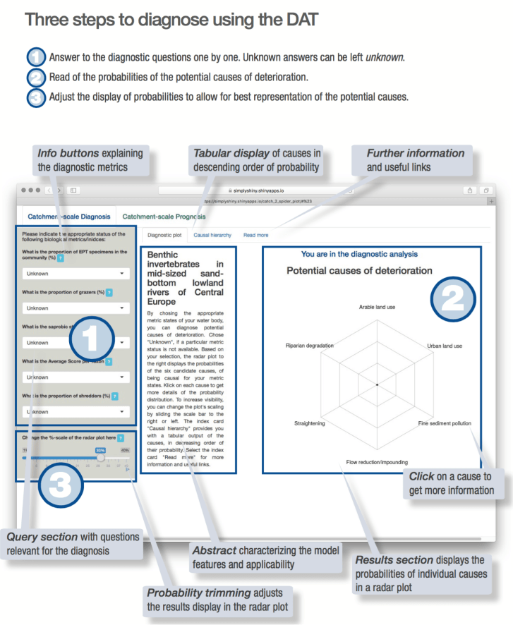
The DAT uses a Bayesian network to calculate the probability of different causes of ecological degradation being present in a water body. This probability can be visualised through graphs and tables. In effect, the DAT works like a doctor’s ‘health check’ for water bodies, in which the causes of illness are diagnosed based on a patient’s symptoms.
The DAT ‘diagnoses’ the probable causes of ecological degradation, based on their inputted ecological ‘symptoms’. Possible drivers of multiple stressors – arable and urban land use, riparian degradation, channel straightening, flow regulation, fine sediment pollution, habitat loss – are ranked in order of probability.

Descriptions of each driver, and possible mitigation approaches, are then provided through the tool’s interactive interface. This provides potentially valuable information for water managers seeking to minimise biodiversity losses and ecosystem alterations in their water bodies.
The DAT has been developed based on MARS research and modelling for mid-sized sand-bottom lowland rivers of Central Europe. However, it can be tailored by interested users to work for other water body types. Full documentation on how to modify the DAT can be found here (pdf) and guidance can be given by MARS scientist Christian Feld by email.
Visualising multiple stressors on European river catchments: the MARS Scenario Analysis Tool

The MARS Scenario Analysis Tool
Over the last four years, the MARS project has been investigating the interactions and impacts of multiple stressors on Europe’s aquatic ecosystems. This is a topic at the cutting edge of freshwater science research, and MARS scientists have sought to understand how the multiple pressures humans place on the environment – nutrient pollution, habitat alteration, climate change, water abstraction, and many more – act together to cause stress on the continent’s rivers and lakes. As a result, this work is important for environmental managers and policy makers seeking effective options to mitigate multiple stresses, and conserve or restore Europe’s freshwaters.
MARS Scenario Analysis Tool
MARS has recently launched its Scenario Analysis Tool – an online, open-source mapping tool, which allows users to visualise and analyse multiple stressor conditions in European rivers. The tool can generate maps showing where different stressors occur, how many stressors co-occur, and their potential impacts on ecosystem status, at both the river basin and the continental scale.
The Scenario Analysis Tool shows that six stressor indicators – 1) dissolved inorganic nitrogen and 2) phosphorous concentrations; surrounding 3) urban, and 4) agricultural land; alterations to 5) annual and 6) base water flows – explain the majority of differences in ecological status across European rivers. MARS researchers also identified ecological thresholds when the impact of multiple stressors tips ecological status from good to moderate.
Current Stressor Patterns in European Rivers
The Scenario Analysis Tool illustrates a number of broad current European stressor patterns. It shows that Southern Europe is significantly more hydrologically stressed than the rest of Europe, particularly in Mediterranean countries as a result of water abstraction for agriculture. There are three or more stressors acting together in half of the European river catchments. Only 9% of European river catchments have no active human stressors acting on them.
Stressor ‘thresholds’ where ecological status is reduced were found in 60% of catchments for agricultural land use stressors, 50% of catchments for dissolved inorganic nitrogen, and 40% of catchments for total phosphorous. This is unsurprising, as nutrient modelling underpinning the tool shows that agriculture is a significant source of nutrient loadings into European rivers.

Visualisations of the multiple stressors impacting individual river basins can be created by users. This complex picture is for the Danube basin.
Storylines for Future Worlds
The Scenario Analysis Tool also allows users to visualise the multiple stressor picture for two future periods – 2026–2035 and 2056–2065 – under two different ‘storylines’ of possible climatic and social change. The two time-horizons have been chosen to inform the update of the Water Framework Directive in 2027 (2026–2035), and to show possible impacts of climate change (2056–2065). The two storylines have been designed by MARS researchers to outline possible future climatic, political and economic trajectories, based on forecasts in the IPCC Representative Concentration Pathways and Shared Socio-Economic Pathways.
The Techno World storyline is based on a scenario of high greenhouse gas emissions and rising global temperatures (Representative Concentration Pathway 8.5) in combination with a strong, carbon-based global economy in which many currently pressing social concerns, such as inequality and population growth, have been mitigated (Shared Socio-Economic Pathway 5).
The Consensus World storyline is based on a scenario where future development follows similar patterns to the recent past: the economy grows well in some countries and poorly in others, and inequality between rich and poor countries continues. Despite this disparity, the world tends towards being relatively politically stable (Shared Socio-Economic Pathway 2). This occurs alongside a stabilising and relatively low level of climatic change (Representative Concentration Pathway 4.5).
In addition to the future ‘storylines’, the Scenario Analysis Tool allows for the effects of three stressor mitigation management approaches – nutrient reductions, riparian buffer strips, and improved waste water treatment – to be modelled.
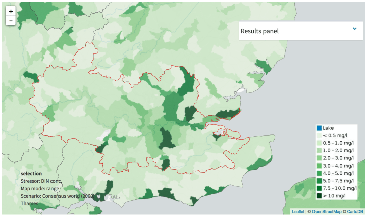
Forecasting dissolved inorganic nitrogen concentrations in the River Thames basin in SE England under the Consensus World scenario around 2060.
Future ‘Storyline’ Stressor Patterns
Both Techno and Consensus World storylines predict that river discharges are likely to increase, on average, across European catchments in the future. The highest increases will occur during high flow season, and the lowest increases during low flow season. However, in several rivers in Southern Europe, discharge in the low flow season will decrease in both storylines.
For both storylines, the probability of rivers reaching good ecological status falls by 3–5% in the future if mitigation strategies aren’t implemented to manage stressor effects. However, this prediction differs with river type. This finding emphasises the need for catchment specific stressor mitigation approaches, rather than a ‘one size fits all’ European water management approach.
Data and Models
The Scenario Analysis Tool is underpinned by two computer models using hydrological, ecological and meteorological data gathered between 2001-2010. The global hydrological model PCR-GLOBWB was used to simulate river flows and runoff across Europe. Water abstraction, reservoir management and domestic, industrial, livestock and irrigation water use are all included in this model. This feeds hydrological data to a second model, MONERIS, which quantifies nitrogen and phosphorus emissions to surface waters, along with their in-stream retention rates, and resulting loads and concentrations.
The results of both models are brought together with data on individual catchments, and the Water Framework Directive reporting data on ecological status by EU member states. The outputs of this computer modelling allows for climate, water availability, nutrient fluxes and management options to be analysed through quantifying and evaluating multi-stressor conditions and aquatic responses across Europe.
The tool was designed and developed by Markus Venohr and Judith Mahnkopf from IGB (DE), supported by Lidija Globevnik (Uni Ljubljana, SI), Yiannis Panagopoulos (NTUA, GR), and Marta Faneca Sanchez and Frederiek Sperna Weiland (Deltares, NL).
Explore the Scenario Analysis Tool
Read the MARS report on the methods, data and results of the Scenario Analysis Tool
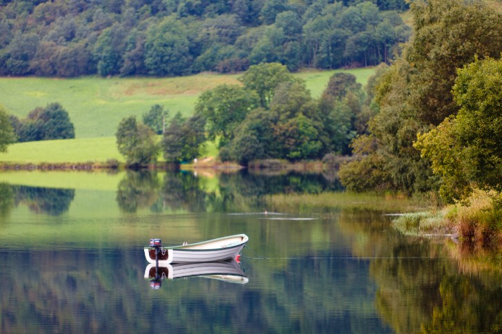
A motorboat anchored on a Norwegian lake. Engine noise, water turbulence and fuel spills can all cause stress to aquatic ecosystems. Image: Henry Leirvoll | Flickr Creative Commons
Rivers and lakes are popular places for people to relax, play and exercise, and recreational activities like boating, bathing and angling are all well-documented to have positive effects on human well-being. But can the enjoyment of such freshwater ‘ecosystem services’ cause pressures on aquatic ecosystems? And how best can recreational activities be managed to minimise the harm they might cause?
A review of available data on the topic recently published in the Environmental Reviews journal shows that environmental quality is closely liked to recreational activities in many freshwater ecosystems. The ecological health and diversity of a river or lake can be an attractive draw for visitors, potentially causing tensions between tourist ‘hotspots’ and areas of conservation importance. This means there is a pressing need for effective management strategies to minimise ecological damage from visitor use in many places.
The new MARS-supported study, led by Markus Venohr from IGB Berlin and colleagues, outlines how recreational activities can cause a variety of physical, biological and chemical pressures to freshwaters. Physical pressures can include the noise and waves produced by boats, damage to riparian vegetation and stream banks and beds by human trampling, camping and wading, whilst boats and canoes can stir up bottom sediments, leading to increased water cloudiness (or turbidity).
Biological pressures can include the spread of non-native species due to angling or boating activities, and increased levels of coliform bacteria (e.g. E. coli), as a result of poorly-treated sewage run-off from nearby campsite toilets. Finally, chemical pressures largely stem from increases in nutrient pollution (e.g. from nearby tourist centres), but also include pollution impacts from soap, sunscreen, food particles, human and animal waste, and fuel discharges.

Campsite beside a Swedish lake. Fuel and waste disposal can cause lake pollution. Image: Jörgen Brouwer
Clearly, there is a geography to such pressures: some are direct and some indirect; some local-scale and others occurring over larger spatial scales. Some activities (e.g. power-boating) will likely create more pressures than others (e.g. wild swimming). Each individual water body will be subject to its own particular socio-ecological ‘cocktail’ of pressures as a result of recreational activities. As Venohr and colleagues put it, the challenge for managers of individual water bodies is to “develop solutions that maximise the well-being of as many people as possible while minimising ecological impacts and therefore reaching ecological quality standards.”
So how can recreational pressures impact ecosystem health and status? Such pressure-impact links are not always fully understood, but have been investigated by a number of recent studies. Motorboat noise has been shown to directly modify fish assemblages, as prey fishes were more easily caught by predators when exposed to noise. Waste water from boats moved between water bodies, and illegal releases of live angling bait and pet fish can both be significant routes for the spread of invasive species across ecosystems (see here (pdf), for example). Recreational angling can impact fish populations in some ecosystems, even after regulations seeking sustainable use, such as catch and release have been implemented (see here and here for example).
Venohr and colleagues propose a new framework for understanding relationships between recreational quality, demand and use, recreational impacts on ecosystem state and function, and ecological and social carrying capacities. They argue that current water management approaches rarely address these relationships, in part due to inadequate information on the dynamics and densities of recreation uses.
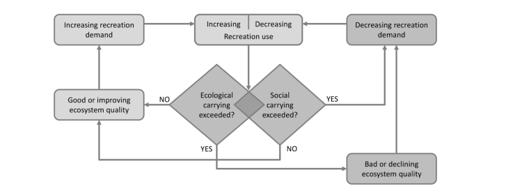
The framework has two parts. The first, shown above, shows the relationships between ecosystem quality and recreational demand. It conceptualises that recreational demand will increase or decrease depending on the ecological quality of the freshwater ecosystem. It uses the idea of ‘carrying capacity’ – the limits to sustainable use of an ecosystem – to highlight where ecological damage or human overcrowding of a site may lead to decreasing recreational demand.
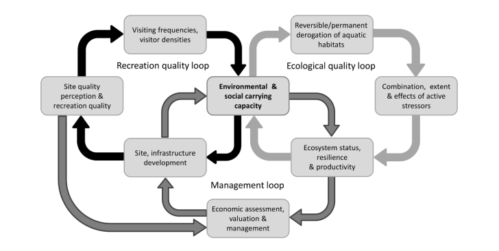
The second part of the proposed framework is a ‘multi-loop’ concept, which links ecological quality and recreational quality with responsive ecosystem management. It illustrates how water managers should monitor visitor perceptions of their water body, and how these influence recreational use. These uses influence (and are influenced by) ecological quality, which should be monitored in tandem. Such a linked, responsive approach will allow managers to encourage sustainable recreational uses, which minimise ecological damage, the authors argue.
Markus Venohr outlines the benefits of such an approach, “This framework provides the basis of a next-generation water management approach. It brings together expertise from different disciplines to generate a joint ecosystem assessment attribute – the social-environment carrying capacity of a water body.”
Venohr and colleagues outline the need for novel assessment and monitoring methods to capture the short-term peak dynamics of freshwater recreational activities. They suggest that geotagged social media posts from Twitter, Facebook, Flickr and Instagram have the potential to illustrate recreational activity dynamics across large spatial scales. Geotagged data from social media posts could allow researchers and water managers to analyse how recreational uses of freshwaters varies depending on weather conditions, time of day, season, and site accessibility.
Whilst such digital mapping of human behaviour is increasingly used in business and political strategy, Venohr and colleagues suggest that it holds untapped potential for water management, providing that social media use can first be calibrated to ‘real world’ conditions through the use of interviews, surveys, cameras, flights or drones.
Markus Venohr concludes, “Our study has three key outcomes. First, we found that recreational peak uses of water-bound activities can potentially cause pronounced stress to aquatic ecosystems. Second, we argue that the links between water quality and recreational use has to better understood and conceptualised across larger geographical scales. Finally, we suggest that better assessment of recreation-induced pressures on aquatic ecosystems is needed, both to achieve water management goals and to increase ecological awareness amongst recreational user groups.”
Macrophyte recovery in eutrophic shallow lakes requires both internal and external restoration measures
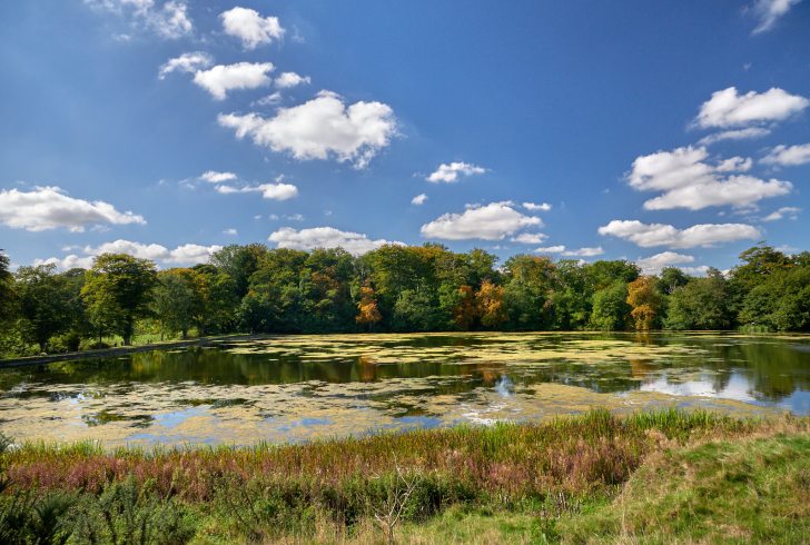
Felbrigg Lake in Norfolk, UK – one of the shallow lake ecosystems in this study. Image: colinsd40 | Flickr Creative Commons
Shallow lakes are the most abundant freshwater ecosystems on earth, and are often characterized by abundant submerged vegetation, which can stabilize clear-water conditions and play a key role in ecosystem functioning. However, eutrophication – often caused by nutrient pollution – has caused increasingly cloudy water conditions in many shallow European lakes over the last century. In many places, such ‘turbid‘ lake waters have resulted in the loss of many submerged aquatic plant communities, which rely on light penetrating the water column to thrive.
Considerable environmental management efforts have been devoted to restoring clear-water conditions in shallow European lakes. However, the successful long-term establishment of stable and diverse aquatic plant (known by scientists as ‘macrophyte‘) communities often fails. As a result, macrophyte recovery patterns following the management of multiple stressors including nutrient pollution are yet to be fully understood.

A German shallow lake with extensive summer cyanobacteria blooms: a typical feature of the intermediate recovery phase during nutrient load reduction. Image: Sabine Hilt
A new open-access study published in Frontiers in Plant Sciences aims to unravel recovery patterns of macrophytes in response to different lake restoration measures. Lead author Sabine Hilt – senior scientist at the Leibniz-Institute of Freshwater Ecology and Inland Fisheries in Berlin – and colleagues from Germany, The Netherlands, Denmark, Sweden and the UK collected and analysed data on water quality and submerged macrophyte communities in 49 temperate shallow lakes.
All studied lakes had deteriorated to a turbid state, and subsequently were subject to either external or internal restoration measures (or both). External restoration measures generally involve the reduction of external nutrient pollution, whereas internal measures include biomanipulation or phosphorus precipitation in an attempt to control eutrophication blooms.
“Based on a few existing case studies, we hypothesized that reduced external nutrient loading would often lead to an intermediate recovery state with clear spring and turbid summer conditions, similar to the pattern described for eutrophication” states Sabine Hilt. Data collected from 21 different lakes supported their hypothesis. In many lakes, clear spring conditions allowed a re-colonisation of macrophytes, but the continuation of strong cyanobacteria blooms, and turbid summer conditions.
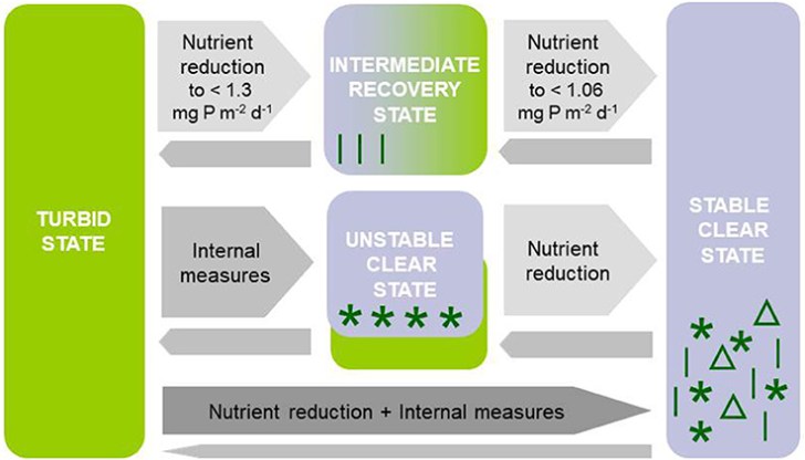
The ecological trajectories and management measures between turbid and stable clear state in shallow lakes. Infographic: Sabine Hilt and colleagues
This situation can be simulated using an adapted version of the ecosystem model PCLake. Model simulations indicate the existence of specific thresholds in nutrient loading for shifts between turbid, intermediate and clear-water conditions.
In contrast to external nutrient load reductions, lake internal restoration measures such as the manipulation of the fish stock often resulted in transient clear-water conditions both in spring and summer. This was shown using data from 28 different shallow lakes. Often, however, lakes returned to turbid conditions.

Sago pondweed (Potamogeton pectinatus) overgrown with periphyton in the recovery period following nutrient load reduction (photo: Sabine Hilt)
Interestingly, the contrasting restoration measures resulted in different macrophyte species compositions. The intermediate recovery state following reduced nutrient loading was mainly characterised by a few pondweeds that can resist wave action (allowing survival in shallow areas), germinate early in spring, have energy-rich vegetative propagules facilitating rapid initial growth, and can complete their life cycle by early summer. In contrast, internal lake restoration measures often coincide with a rapid but transient colonisation by hornworts, waterweeds or charophytes.
The authors conclude that the composition of the macrophyte community and their seasonal abundance in shallow lakes during recovery from turbid, highly eutrophic conditions often depends on remnant macrophyte stands, the specific restoration measure applied, and additional stochastic influences on water clarity such as winter fish kills, cormorant predation on fish or introduction of invasive filter-feeding mussel populations. In turn, the prevailing macrophyte community can influence lake water quality. Their study suggests that lasting macrophyte recovery in shallow lakes can only be achieved when internal restoration measures are combined with reduced external nutrient loading.
The Beauty in the Bog
Peat can be cut or mined from peatlands for use as fuel, for growing plants, insulation, packaging and beauty treatments. But the bare peat left behind doesn’t support much life. Credit: nz_willowherb, Flickr, CC-BY-NC 2.0
A guest post by Dr Claire Wordley from Conservation Evidence.
Soggy, centuries-dead plants may not sound like they should be a global conservation priority. But peatlands – soils where water saturation prevents organic matter from fully decaying – store 500 billion metric tons of carbon worldwide. That’s more per metre than rainforests, and the equivalent of half of the carbon that is currently in the atmosphere. Peatlands also contain a wide variety of animals and plants, some of which only live in these wet habitats. Bitterns and bearded tits, ruffs and phalaropes, even tigers and orangutans, all call peatlands home.
Healthy peatland vegetation is fundamental to capturing carbon, housing biodiversity and regulating water cycles. This week, an online resource collecting the evidence for what works (and what doesn’t) to conserve and restore peatland vegetation has been published. This is the first chapter of the ‘wetland synopsis’, a three year project to gather the global evidence for the effects of interventions to conserve plant communities in all types of wetlands, run by researchers at Tour du Valat in France in collaboration with Conservation Evidence at the University of Cambridge in the UK.
Across the world, peat has been dug up to add to compost in garden centres, dried out to allow the planting of timber or crops, or even mined as a fuel to burn. As the peatlands are exploited, wonderful and fragile ecosystems are lost. The Dutch landscapes of polders and windmills? Built to keep water out of drained peatland. East Anglia’s arable desert? Once wet fenland on peat soils. Oil palm plantations in Indonesia? Planted after the lush peat swamp forests were cut and burned. But this is not the end of the story; people are working hard to conserve peatland vegetation, and even restore it to some places where it has been lost.

A healthy peatland can contain a mix of mosses, shrubs, trees and open water. Boardwalks allow people to explore and enjoy the bog without damaging the plants. Credit: Tania & Artur, Flickr, CC-BY-NC-ND 2.0
The ‘peatland synopsis’ collects together and summarises the evidence for 120 different ‘interventions’, actions that conservationists might take to conserve or restore vegetation on wet peat soils: areas like bogs, fens and peat swamp forests. The authors, led by Nigel Taylor, gathered scientific papers from over 220 journals, plus unpublished reports by NGOs and governments. Experts then scored the evidence for each intervention, to estimate the benefits of that intervention, any harms arising from it, plus the certainty in the evidence. The results are available for free on the Conservation Evidence website, and those related to restoration can also be found on the Restoration Evidence website, a new site devoted to collecting the evidence for the restoration of habitats globally.
So what can be done to stop the draining of the swamps, and to restore those that have been drained? The gathered evidence can show us the best strategies. ‘Rewetting’ peat, for example by blocking drainage ditches, was the intervention with the most evidence by far. It led to the recovery of bog and fen vegetation in many studies. Removing trees (usually plantation forests) along with rewetting, also tended to increase typical high-latitude peatland vegetation such as Sphagnum moss, cottongrass and sedges, although the precise effects depended on the site. Spreading mosses and other plants over bogs and fens often led to the establishment of typical bog and fen species, although again the success rates varied.
There are large areas of peat swamp in the tropics. It is important to monitor the effects of any conservation interventions, and report the results so others can learn what works and what doesn’t. Credit: CIFOR, Flickr, CC-BY-NC-ND 2.0
Some interventions, however, appeared not to work very reliably. Planting ‘nurse plants’ for peatland vegetation didn’t seem to help (in either tropical or boreal studies). Creating mounds or hollows in the peat surface before planting vegetation didn’t affect Sphagnum cover in Canadian studies, although one study in peat swamp in Thailand reported that planting trees into mounds of peat led to thicker stems. Adding root-associated fungi to plants before planting didn’t work for most of the 15 Indonesian species in which it was studied; however, in one study, some fungal treatments did slightly increase the growth and survival of one species.
There are many things we can do to help peatlands, as researchers, conservationists and individuals. Researchers can test more interventions that might be used to conserve and restore peatland plants – for over half the interventions studied, no evidence was found, and very few studies were found from tropical peatlands. These all represent important knowledge gaps. Conservationists can use the available evidence to make the best possible decisions about what to do with their peatland, and, where possible, test the interventions that they are undertaking and publish the results. Individuals can avoid buying compost containing peat (look for peat-free logos) and avoid palm oil, or buy certified sustainable palm oil products instead. And we can all learn to appreciate swamps, bogs and fens; if you live near a peatland nature reserve then visit, and marvel at the beauty in the bog.
Messages from MARS

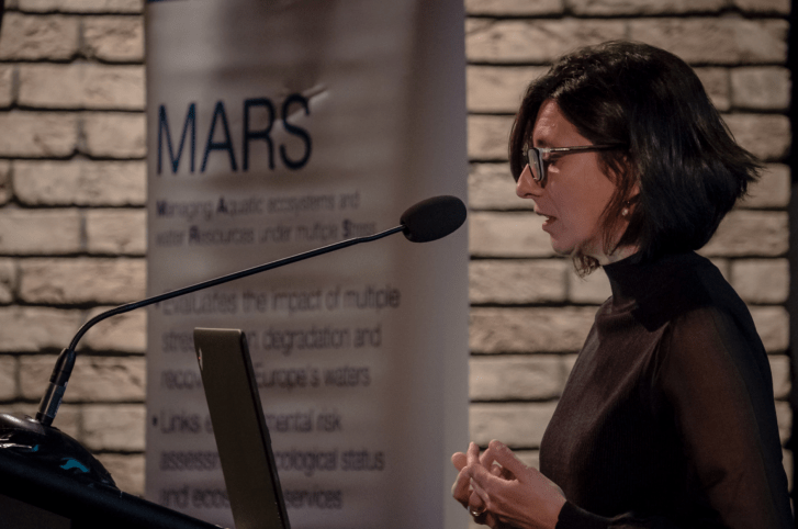
MARS leader Daniel Hering addresses the final project conference in Brussels. Image: Jörg Strackbein
The EU FP7 MARS Project – “Managing multiple stress for multiple benefits in aquatic ecosystems” – celebrated its final conference in Brussels last month. On the 16 and 17 January 2018, around 150 water scientists, managers and policy-makers convened in the time-honoured halls of the Museum of Natural Sciences, Brussels.
The event concluded four years of in-depth research by MARS scientists on multi-stressor effects on European surface and ground waters, highlighting the implications for Water Framework Directive (WFD) related management.
Ana Cristina Cardoso speaking to the MARS conference. Image: Jörg Strackbein.
Among the array of fascinating results generated by the MARS project, four key messages were reported at the conference.
+++
Message 1: Mitigating pressure-effects on aquatic ecosystems requires an understanding of multi-stressor impacts.
WFD water management is designed using the Driver-Pressure-State-Impact-Response concept. Significant pressures on aquatic ecosystems are identified first. These pressures are assumed to have impacts on ecological status of a river, lake or groundwater. Mitigation actions are then selected on the basis of these pressures (known as the “pressure-response shortcut”).
This approach may not fully account for the complex interactions and impacts of multiple stressors. As a result, MARS advocates aquatic science research that investigates the direct causes of deteriorated ecological status. Such an approach would allow for more informed management decisions targeting the actual, multi-stressor reasons for ecosystems not reaching good status.

Multi-stressor/impact relationships lie at the heart of informed river basin management. The WFD monitoring programmes generate valuable data sources for such analysis. EQR = Ecological Quality Ratio; ESS = Ecosystem Services.
+++
Message 2: Environmental ‘noise’ can obscure evidence from multi-stressor/impact relationships in river basins. Experiments can help unravel multi-stressor interactions and impacts.

Multi-stressor evidence at the river basin scale (most relevant for water management) is more obscure compared to the evidence gained at experimental scale (under controlled conditions) or European scale (with many and long stressor gradients).
Water managers deal with water bodies in the ‘real world’. Here, multi-stressor effects on aquatic biology often interfere with other (natural) factors like weather conditions or river flow dynamics.
Distinguishing multi-stressor effects from such complex environments is a bit like trying to identify a musical tune played in a noisy room. Nevertheless, water managers need to understand the multi-stressor combinations acting in their basin to devise appropriate mitigation measures.
Multi-stressor experiments (like those conducted by MARS in the Austrian Alps) help uncover the ‘noise-free’ pathways of multi-stressors interactions and impacts, and thus offer valuable insights for informed management decisions.
+++
Message 3: Multi-stressor interactions are common in rivers and lakes across Europe and need to be considered in River Basin Management. Interactions are highly context-specific, requiring targeted, localised research to inform management.
 About one-third of the 156 MARS case studies studies analysed showed significant interaction effects (in paired-stressor/impact relationships). The strength of interaction effects at river basin scale is as large as at experimental scale.
+++
Message 4: River Basin Management in Europe will benefit from (more) data-driven analyses, modelling and interpretations which are tailor-made for the river basin to be managed.
WFD monitoring data from surface and ground waters across Europe is increasingly available, allowing researchers new opportunities to analyse multi-stressor/impact relationships. This evidence can feed into basin-specific prognostic or diagnostic models that enhance our understanding of aquatic systems, and help facilitate their effective management. Practitioners from applied aquatic science and water management can work together as interdisciplinary ‘water body doctors’.
MARS is helping create the conditions for such work by offering:
- An introduction to multiple stressors in aquatic ecosystems;
- A multi-stress analytical ‘cookbook’;
- A model selection tool;
- A diagnostic tool;
- A scenario analysis tool;
- Guidance for River Basin Management under multiple stress (coming soon).
+++
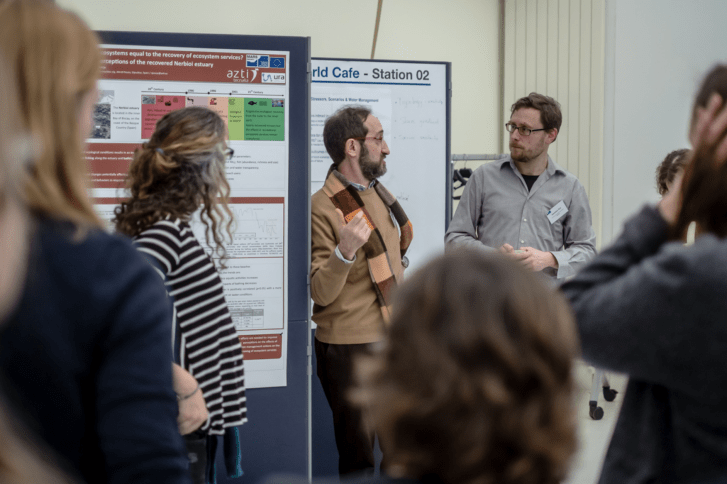
Sebastian Birk (right) in conversation with Angel Borja at a ‘World Cafe’ session. Image: Jörg Strackbein
Summing up, MARS researcher Sebastian Birk is hopeful about the impacts the project can continue to have, “This final conference of the MARS project inspired the renewal of our Hippocratic oath ‘first not to harm’ but to be beneficial to our water resources. We feel confident that our project built bridges towards closing the gap between science and practice when it comes to more effective water management under multiple stress.”
Meet the AQUACROSS team: Asya Marhubi
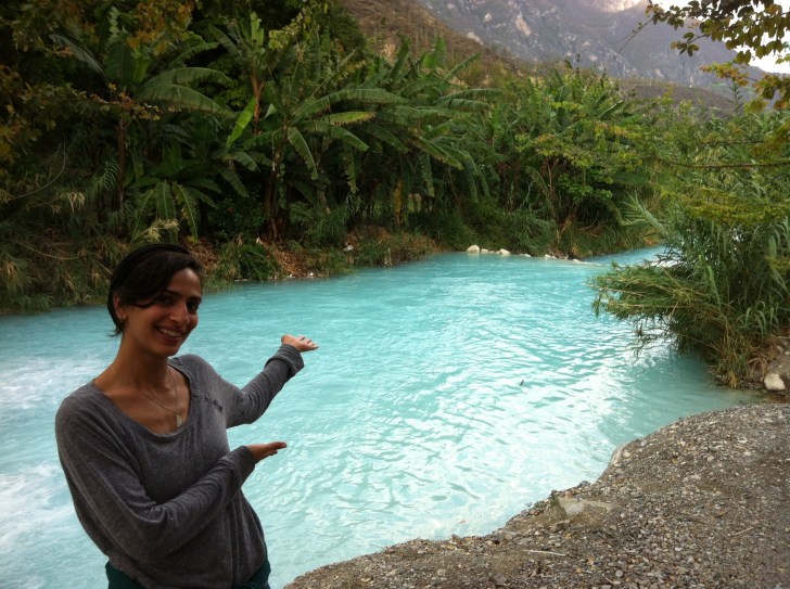
Asya Marhubi at Grutas de Tolantondo, México.
This week we continue our series of interviews with researchers from the EU AQUACROSS project by talking to Asya Marhubi. Asya works for IMDEA Water in Madrid, Spain on research support for the AQUACROSS project. She has an interdisciplinary background encompassing International Development Studies, Spanish and Latin American Studies and Corporate Social Responsibility.
We spoke to Asya to find out more about her work.
Freshwater Blog: What is the focus of your work in AQUACROSS, and why?
Given my academic background on international development my focus has traditionally been on socioeconomic development, however the fate of the two are inextricably linked with that of the environment, and concerns regarding climate change and environmental conservation have been ubiquitous throughout my education and professional career.
For this reason, within AQUACROSS, my work has been centred on the socioeconomic system, focusing on policy orientation under WP2, supporting the development and update of the AQUACROSS Assessment Framework under WP3, and contributing to work being performed on drivers of change under WP4.
Why is your work important?
It contributes towards deepening our understanding of the links between ecological and socioeconomic systems, and of the wellbeing benefits that are provided by a healthy ecosystem. I believe that through strengthening the understanding of the links between the two systems is crucial in order for us to move closer to holistic approaches to environmental management that give appropriate weight to the value of goods and services provided to us by the environment.
What are the key challenges for aquatic management in Europe?
From my perspective, one of the key challenges of water management in Europe is the negotiation of trade-offs between different water uses and users (including the environment), especially under the context of climate change adaptation and increasing water scarcity.
This context also brings into the foreground the rising need to decouple water use and economic growth in order to ensure that the global quest for socioeconomic development does not come at a disproportionate cost to the environment, and to the legacy left for future generations.
Tell us about a memorable experience in your career.
In addition to my work at IMDEA Water, over the past year I have had the opportunity to manage social media and other dissemination activities for the Foro de la Economía del Agua (Water Economics Forum).
Through this initiative I have had the opportunity to hear from numerous Nobel Prize Laureates and international experts of world renown on a wide array of topics related to water resource and service management, such as George Akerlof, Gro Harlem Brundtland, Mohan Munasinghe, Michael Hanenmann…to name just a few.
What inspired you to take your career path?
My interest in global issues stems from my childhood; growing up as an Omani citizen to British and Zanzibari parents, I saw first-hand the stark differences between my family’s life in Oman, and those of my relatives living in Zanzibar, and England. After beginning my undergraduate degree in International Development, and Spanish & Latin American Studies in 2006, I have come to appreciate that the disparity within my own family is a result of a large, and intricate set of systems.
Through my academic, personal and professional experiences, I have sought to gain a deeper understanding of these systems that shape our lives. I believe that their complexity requires us to adopt a holistic and collaborative approach, in order to change the nature of these systems for the better.
What are your plans and ambitions for your future work?
International development is an inherently interdisciplinary field, and fundamentally, this has given me the opportunity to study and work alongside people from diverse academic and cultural backgrounds. Given the complexity of the today’s global issues, and their ever-evolving nature, especially in the digital and globalised age, I believe that this is an essential skill.
And while I do not know exactly where my career will take me, it is my hope to contribute to bridging the gap between natural and social sciences, and to championing the adoption of holistic and interdisciplinary perspectives and approaches to the challenges we face.


