‘Blue spaces’ help improve public health

Spending time near water has even greater health benefits than visiting a forest or park, according to researchers. Image: Frederica Diamanta / Unsplash
A post from our partners at Horizon: the EU Research & Innovation Magazine.
–
Living close to bodies of water such as a river or even a fountain can help improve public health, whilst also reducing medical costs for governments, according to researchers.
There is growing evidence that spending time in the natural environment can foster important mental and physical health benefits, and help prevent illness and reduce medical bills. One study found that people in England made 1.23 billion active trips to parks and woodlands, which was estimated to be worth £2.18 billion in terms of annual health benefits.
Now research by the same team suggests that so-called ‘blue spaces‘ – areas with water features like a river, ocean, spring, or even a fountain in a city centre – could be particularly beneficial.
‘What we find time and time again is that being exposed to blue environments often has even greater (health benefits) than visiting a green space (like a park or forest),’ said Dr Mathew White, an environmental psychologist at the University of Exeter, in the UK, who helped conduct the research.
One reason is that people who take trips to bodies of water are more likely to also go for longer walks or cycles – as well as swimming – which can help lower their risk of developing chronic disease like diabetes, heart disease and cancer. But water can have other benefits too.
‘Blue spaces can directly reduce psychological stress and improve mood,’ said Dr White, who is also a lead researcher in BlueHealth, an EU project examining the relationship between this type of blue infrastructure and people’s health and wellbeing.
The reasons why water is mentally therapeutic may be connected to the open vistas, reflected light and associated soundscapes, according to the researchers. Depression has also been linked to detachment from the natural environment so blue spaces are useful for ‘reducing the negative and improving the positive,’ said Dr White.
The mental and physical benefits of blue spaces may seem obvious to the 200 million people in Europe who live close to the coast. However, to help the general public embrace the full health benefits, it requires specifically designed ways of safely accessing and appreciating blue spaces.
‘One thing we are interested in is how to quantify blue spaces so we can put an economic value on them to justify infrastructure investment,’ said Dr White.
BlueHealth is aiming to gather data to help convince policymakers to invest in blue spaces, particularly in urban areas. They recently conducted an international survey asking 18,000 people about the kinds of activities they do in blue spaces across Europe, in an attempt to determine the implications this has for public health. The results are expected later this year.

A new coastal amphitheatre in Plymouth, UK, will allow school children to spend more time by the water. Image: BlueHealth
‘Urban acupuncture’ to connect communities to water
BlueHealth is also working on innovative ways to increase public access to blue spaces, from using virtual reality for those physically unable to make the journey to the ocean, to improving access through local community interventions termed ‘urban acupuncture’.
Urban acupuncture is an urban planning concept that involves working with local communities to make small adjustments to bodies of water to connect the potential physical and mental health benefits to the public. This can include a viewing platform along a lake or a pathway to a river.
Improving access to water, however, does increase risks such as public exposure to flooding, or potential drownings if a blue space is left unsupervised. However, according to Professor Lora Fleming from the University of Exeter and the principal investigator of BlueHealth, ‘natural environments have both risks and benefits’, but you can still improve access to blue spaces with these in mind.
In one of several case studies across Europe, BlueHealth researchers worked with Plymouth City Council on England’s south coast to help regenerate an area along the seafront in an attempt to boost local health and wellbeing. By engaging with local residents and stakeholders, they helped build a small coastal facing amphitheatre and safe playing area for children, which will host special family events and school sessions run by, among others, the local aquarium and wildlife trust.
The researchers also considered the potential impacts of rising sea levels due to climate change and coastal erosion, building the theatre in such a way as to protect it for decades to come.
Projects designed like this can help to connect children with the natural environment for generations and improve their health and wellbeing over their lives, but in order to be successful, local communities need to be involved. ‘Otherwise they won’t use it,’ said Prof. Fleming.
Working with local people when developing blue space access can also bring environmental advantages, according to Professor Sheila Heymans, the executive director of the European Marine Board (EMB), a research think-tank specialising in marine science policy.
She believes that once people begin to appreciate blue spaces more they will want to protect them from pollution, overfishing and poor urban planning. But to design ways of providing safe access to blue spaces that incorporates all these factors will require significant investment, from researching the local needs to choosing a site and then the actual construction.
Supporting human and environmental health through ‘blue thinking’
‘There isn’t a single place where blue spaces are actually coordinated from,’ Prof. Heymans said. ‘Incorporating blue spaces very much depends on one or two people in the local authority.’
Prof. Heymans believes that government policies need to be moulded so that they complement each other and support more ‘blue thinking’ across sectors such as health, environment, tourism, and transportation.
‘Some of the policies and directives in Europe are counterproductive, the habitat and bird directives expect you to save seabirds, but the reduction in discards from the reform of the common fisheries policy will reduce food for seabirds that are dependent on these discards, so different policies can sometimes work at cross purposes,’ said Prof. Heymans.
Policymakers therefore need specific information that can help convince local authorities about the combined potential environmental, economic, social, and health benefits.
The EMB are now working with the Exeter BlueHealth team to coordinate a new project called SOPHIE, which is examining how the marine environment and human health are inextricably linked.
‘There is a link to the health of humans to the health of the oceans,’ said Prof. Heymans. ‘You need to fund interdisciplinary research to make that clear.’
More information:
The Alliance for Freshwater Life is launched
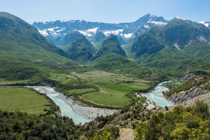
The Vjosa river and floodplain in Albania: one of the last intact large river systems in Europe, currently threatened by proposed dam construction projects. Image: Lukas Thuile Bistarelli
A new global network aiming to halt and reverse the ongoing freshwater biodiversity loss crisis launched last Sunday at the World Water Week conference in Stockholm. The Alliance for Freshwater Life is an interdisciplinary network of scientists, conservation professionals, educators, policy experts, creative practitioners, and citizens working to improve the conservation and sustainable use of freshwater ecosystems and biodiversity.
Freshwaters are some of the most biodiverse ecosystems in the world, many supporting populations of rare and endemic species. However, freshwaters are also impacted by multiple pressures, many of which stem from human activities. Freshwater ecosystems are a fundamental resource for human life, providing water, food, energy and natural materials. However, growing pressures such as the pollution, over-abstraction, fragmentation and alteration of water bodies, and the spread of invasive species, habitat loss and alteration – all shadowed by the emerging effects of global climate change – are placing enormous stress on freshwater life.
As a result, freshwater vertebrate populations have declined by more than 80% over the past 50 years – a rate of decline twice that recorded for either marine or terrestrial systems – according to a 2016 World Wide Fund for Nature report. Approximately one-third of the 28,000 freshwater species assessed for the IUCN Red List is threatened with extinction. An estimated three‐quarters of the world’s inland natural wetlands were lost during the 20th century, according to a 2014 study by Nick Davidson. Staggeringly, a 2017 World Economic Forum report ranks freshwater supply as third in a list of the top‐10 global risks, behind weapons of mass destruction and extreme weather events. It is such symptoms of a global freshwater biodiversity crisis that the Alliance for Freshwater Life has been formed to address.

Delegates at World Water Week 2018 in Stockholm. Image: Thomas Henriksson / SIWI
Reflecting on the Stockholm launch, Alliance co-chair William Darwall says, “The showcase to launch our new initiative was well attended despite our 9am Sunday morning time-slot, receiving extensive endorsement and interest from a wide range of organisations present. We received many excellent ideas during the discussions session to help guide our next steps in taking the initiative forwards. We thank all those who attended and for their ideas and support.”
Darwall – Head of the Freshwater Biodiversity Unit at the IUCN Global Species Programme – continues, “The importance of this new initiative was confirmed through much of the dialogue during the week where the need for better representation of freshwater life in water policy and conservation action were abundantly clear. The event was supported by the publication of our paper in Aquatic Conservation: Marine and Freshwater Ecosystems in the previous week, which has already received tremendous interest through social media.”
The newly published paper – available here – is a manifesto for positive action for freshwater biodiversity conservation and policy. It outlines the Alliance’s vision of a global collaboration between national and international organisations and individuals which brings together expertise on education, outreach, research, conservation, and policy-making for the sustainable management of freshwater biodiversity.
The authors identify two key drivers of the ongoing crisis of freshwater biodiversity loss. First, they highlight the significant growth in global demand for water resources over the last century, leading to widespread freshwater habitat loss and degradation, water pollution and over-abstraction, and considerable alterations to the flow and course of many rivers and streams. The authors cite studies suggesting that global demands for drinking water, hydropower and agriculture will increase significantly in coming decades.
Second, the authors argue that existing environmental policies do not adequately protect freshwater biodiversity and ecosystems. They state that the human valuation and usefulness of freshwaters is often foregrounded in environmental policy, at the detriment of non-human life. This, they suggest, often leads to “the unnecessary and often inadvertent sacrifice of freshwater life as collateral damage in global development, which can lead to the destruction of the very ecosystems required to support these same objectives.” In short, the paper argues that whilst human pressures on freshwaters continue to increase and interact, existing environmental policies don’t adequately address their impacts.

Pacific salmon migrating upstream. Salmon populations are threatened by dam construction, mining, over-fishing and climate change. Image: Jason Ching / World Fish Migration Day
In response, the paper outlines five key areas of work to be undertaken by the Alliance to raise the public and political profile of freshwater issues. More research is needed to understand the distribution and status of freshwater biodiversity and ecosystems globally, in order to design effective conservation and restoration initiatives. Freshwater biodiversity data should be better synthesised and made accessible to conservation practitioners.
The core focus of the Alliance is to develop a global network and community of practice for freshwater biodiversity conservation, which fosters collaborations to design and implement large‐scale conservation actions. There is relatively low public awareness of the threats to freshwater ecosystems, and resulting biodiversity loss (a trend which has underpinned the work of this blog over the last eight years), and the Alliance plan to host a range of education and outreach activities to address this shortfall. Finally, the Alliance is designed to provide a voice for freshwater life in global policy making, and its members plan to engage with policy makers both on the implementation of existing policies, and the development of new ones. The aim here is to place freshwater species and their ecosystems on the global agenda as key targets for conservation action.
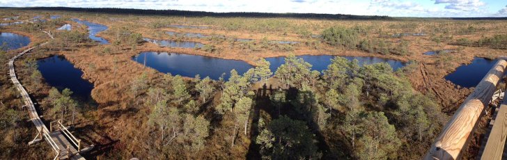
Wetlands in the Kemeri National Park, Latvia. Around three‐quarters of the world’s inland natural wetlands were lost during the 20th century, according to a recent study. Image: Dmitrijs Kuzmins, CC BY 3.0
Darwall outlines the way forward for the Alliance, “The next steps are to fully develop and formalise the strategic plan and to obtain setup funding for the next two-year period during which time we will expand our membership to be globally representative, develop new partnerships, and start work to raise public awareness of the crisis facing our freshwater life.”
Darwall continues, “This exciting new initiative creates an opportunity to step up actions to ensure this growing coalition of organisations and individuals provides the critical mass required for the effective representation of freshwater biodiversity at policy meetings; to develop solutions balancing the needs of development and conservation; and better convey the important role freshwater ecosystems play in human well‐being. Through this united effort we hope to reverse this tide of loss and decline in freshwater biodiversity.
“In the context of the current call for a Paris-style agreement to save life on Earth, calling for a massive increase in our efforts save life on Earth which is in crisis, we have formed the Alliance for Freshwater Life as an endeavour specifically focused on saving freshwater biodiversity, which remains the least poorly appreciated, least funded, and most heavily threatened and declining of all biodiversity, and risks being largely absent from future global agreements – despite contributing a disproportionate amount to the global needs of humans.”
+++
The World Water Week Showcase was convened by Leibniz Institute of Freshwater Ecology and Inland Fisheries (IGB), IHE Delft, International Union for Conservation of Nature (IUCN), World Wide Fund for Nature (WWF), Conservation International (CI), Alliance for Global Water Adaptation (AGWA), National Great Rivers Research and Education Center (NGRREC). The Showcase was sponsored by Leibniz IGB. Outreach and social media development was funded by NGRREC.
+++
Read more:
More Postcards from Heatwave Europe

Low water levels on Thirlmere in the English Lake District in late July 2018. Image: Stephan Brzozowski
We recently published the first in a series of ‘Postcards from Heatwave Europe‘, in which aquatic scientists from across Europe offered their observations on how this summer’s extreme weather was affecting rivers and lakes in their local landscapes.
Today we have two more contributions to the series, from Sweden and the English Lake District. In Britain, at least, the weeks of hot, dry weather experienced this summer have recently been replaced by more unsettled conditions and regular thunderstorms. However, water levels in many lakes and rivers have yet to return to typical summer levels as a result of the prolonged dry spell.
You can read the first set of ‘postcards’ here.
–
Sweden
In the Swedish county of Uppland, we have been racing to complete fieldwork for the BiodivERsA-facilitated CROSSLINK project before our streams dried out or went into extreme low flows. Fortunately, there was good snowfall over winter which meant the streams all started with high base-flows in spring. However, it is not difficult to imagine a scenario where a poor snow year coincides with another extremely dry summer, which could place catastrophic strains on systems already under pressure from human activities.
Notably, the spring transition this year was extraordinarily rapid, leading to record warm temperatures in May. This warming seemingly bolstered seasonal emergence of stream insects, leading to a noticeable pulse of riparian insect activity around our study sites early in the season. We hope to quantify the effects of this spatial subsidy on receiving terrestrial consumers using biomarker analyses.
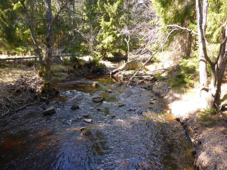
A stream study-site near Uppsala in early May 2018. Image: Francis J. Burdon
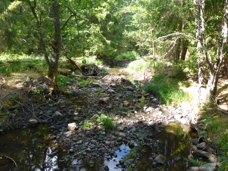
Extreme low flows in the same stream in late June 2018 after a long period of hot, dry weather. Image: Francis J. Burdon
Another aspect of the CROSSLINK project is assessing the benefits of woody riparian buffers to stream ecosystems. In this year’s heatwave, our buffered sites in Sweden have been on average 0.5°C cooler than the un-buffered sites upstream. This observation adds further credence to calls for riparian plantings as a climate adaptation tool in catchments facing multiple pressures. However, we have noticed that our forested headwater reference sites all face hydrological challenges during the summer months. Whilst this natural feature of our systems has likely been exacerbated by drainage practices, there may also be a perverse tradeoff between the benefits of shading and the transpiration exerted by trees.
The severity of the drought in Sweden has caused an unprecedented number of wildfires throughout the country. Our study sites have not been affected, and with temperatures starting to cool and some much-needed rain, the situation seems to be stabilising. Similar to reports from Wales, we have experienced torrential thunderstorms in the past two weeks, leading to surface flooding in urban areas of Uppsala. However, like the situation in the UK, these rain events have only marginally improved the low-flow conditions in our streams. It is safe to say we wait with bated breath to see what more the weather will deliver in 2018.
Dr. Francis J. Burdon, Swedish University of Agricultural Sciences
–

Dry lake bed at Thirlmere in the English Lake District. Image: Stephan Brzozowski
England
The height of the ‘heatwave’ broke here in mid-July, and a threatened hose-pipe ban has been postponed thanks to some rain, cooler temperatures and a drop in water demand. However the hot, dry conditions through May, June and early July – with average air temperatures 2 – 2.5°C above the 1981 – 2010 average and rainfall being only between a third and just under three-quarters of the average for this time of year – have meant water levels in our lakes and rivers have declined.
By the end of July, river levels in a number of the rivers in the northwest of England were at historically low levels and reservoir stocks were much lower this year, particularly in Cumbria and the Lake District where levels were 10 – 30% lower than on average. So what are the impacts of these hydrological and meteorological conditions on some of the lakes in the Lake District?
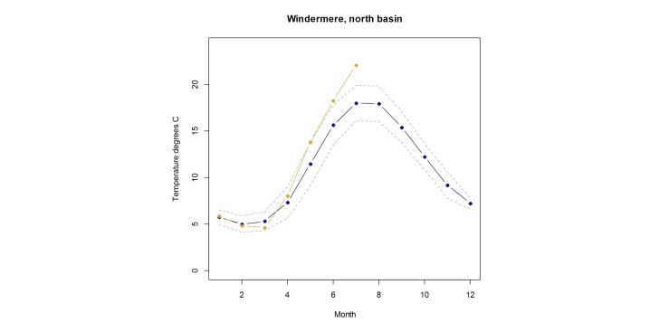
Figure 1: Surface temperature data from Windermere, north basin. The blue line represents the 1981–2010 average, and the dotted lines one standard deviation from this average. The yellow line represents the 2018 data. All data are from the CEH Cumbrian lakes long-term monitoring programme.
At CEH we have been monitoring lakes in the Lake District since the 1940s, so we’re in a good position to see how this year fits into the longer-term pattern. We can see by looking at our long-term record of surface water temperatures, that average temperatures during May, June and July 2018 were between 2.4 and 4°C higher than the 1981–2010 average. (See the example from Lake Windermere’s north basin in Figure 1).
The additional heating of the surface waters also means that the seasonal water column temperature stratification is particularly strong this year, meaning the difference in temperature between the surface and deep water of Windermere is around 16°C, which also has implications for aquatic life in the lakes.
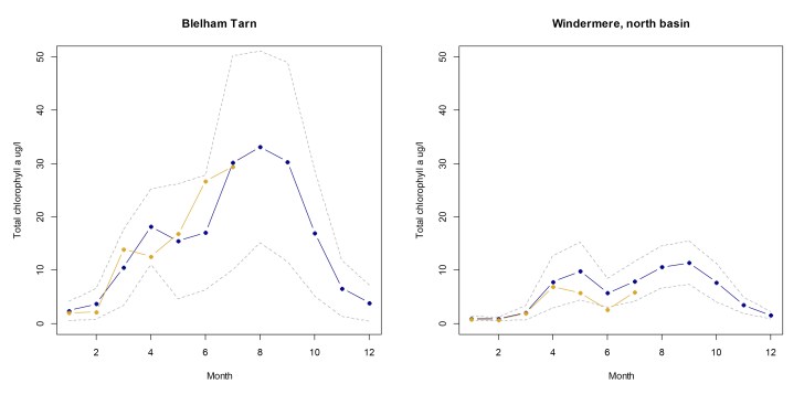
Figure 2: A measure of total algal biomass, chlorophyll a, for Blelham Tarn and Windermere, north basin. The blue line represents the 1981 – 2010 average and dotted lines are 1 standard deviation from the average. The yellow line represents the data from 2018. All data are part of the CEH Cumbrian lakes long-term monitoring programme.
Interestingly, the warmer water has not – during this early part of summer at least – increased the overall amount of algae in the lakes. One measure of algae levels – total chlorophyll a – is not generally above the long-term average (See Figure 2).
At first this may seem at odds with the incidences of cyanobacteria blooms that have been reported for a number of Lake District lakes. However, these species of algae – or more strictly speaking, photosynthetic bacteria – are particularly well adapted to the warm, stable water column conditions that we have been experiencing, because they have the ability to float to the surface and out-compete other species for light. Their buoyancy also means that they can be readily moved by water currents into shoreline areas where they accumulate and become a problem for humans and other animals.

Examples of some of the cyanobacterial genera present in the Cumbrian lakes Windermere and Esthwaite Water this summer. From top left clockwise: Microcystis, Anabaena (straight form), Anabaena and Woronichinia, Anabaena (coiled form) and Aphanizomenon. Image: CEH
Our algal community data suggest that this group are particularly dominant this year, with cyanobacterial genera Anabaena, Aphanizomenon, Woronichinia and Microcystis being present in the community. The lower amount of algae that we have seen this year compared to the long-term average, is likely to be a response to the nutrients available, which enable the algae to grow.
The depletion in the surface water concentrations of these nutrients has been particularly rapid this year, which may be limiting the overall amount of algae that is being supported. The more recent rainstorms at the middle to end of July may have altered this availability by bringing in nutrients from the lake catchments, which could promote more algal growth over the remainder of the summer.
Dr. Ellie Mackay, UK Centre for Ecology & Hydrology, Lancaster, UK.
–
Postcards from Heatwave Europe
Low water levels on Lake Nisser in Norway. Image: Anne Lyche Solheim
Across the world, this summer’s weather has been characterised by extremes. The USA has experienced severe droughts and wildfires in the West, and flash flooding in the East, whilst an ‘unprecedented’ heatwave in Japan has been attributed as the cause of over 65 deaths.
Most of Europe has experienced an extended period of high temperatures and minimal rainfall, causing wildfires to spread in both the Arctic Circle and Greece. Meteorologists predict that the European temperature record of 48C (118.4F) set in Athens in July 1977 could be broken this weekend in Spain and Portugal.
In Europe, the heatwave has been caused by the stalling of the northern hemisphere jet stream, which generally brings cooler Atlantic weather over the continent. As a result, a huge ‘pocket’ of hot, dry air has been present over Europe (particularly northern regions) in recent months.
Analysis of the heatwave in northern Europe between May-July of this year by the World Weather Attribution group suggests that this extreme weather has been made at least twice as likely by ongoing climatic changes. Similarly, speaking recently to The Guardian about this year’s global weather extremes, climate scientist Prof. Michael Mann, at Penn State University said, “This is the face of climate change. We literally would not have seen these extremes in the absence of climate change.”
The high air and water temperatures, low rainfall and flashy storms and flooding experienced across Europe are all key pressures on the health and status of freshwater ecosystems. To gain a picture of how this summer’s weather is affecting European waters, we put a call out to our network of aquatic scientists across the continent, asking them to send in brief ‘postcards’ of their observations.
The first responses are collected here, and more will be published in the coming weeks. If you would like to submit your own observational ‘postcard’, please email info@freshwaterblog.eu
–
Water levels in tributaries of Lake Nisser in Norway are extremely low, and in some cases completely dry. Image: Anne Lyche Solheim
Norway
I am currently on holidays close to Norway’s 10th largest lake (Nisser in Telemark) where the water level is extremely low, and most of the tributaries have dried out completely, or have become reduced to minor streams. Yesterday, a farmer in the local neighbourhood came with his tractor and a big water tank to get water from the lake for his cattle, who are suffering in a grazing area in the hills, where all the streams have tried out. This has never happened before.
The well we use for water supply to our summer house here have lost two-thirds of its water, so we don’t know how long we can stay here before the well runs dry. There is absolutely zero re-charge over the past weeks and months now. 12th of June was the last time we had any substantial rain in South-Eastern Norway.
The air temperature during daytime varies from 28 to 31C, and it’s been like that since mid-May. There are almost no insects, except a few bumble bees. The grass is mostly yellow and the grain crops are likely to be < 1/3 of normal. There is a crisis for cattle farmers, as they do not have enough fodder for them, so a lot has been slaughtered.
The surface water in the lake is now 25C, which is highly exceptional (although perfect for swimming). The littoral zone is completely dried out.
–
Turkey
The weather has been completely weird this year! We had no winter: no snow, no rain, and very dry and warm weather. Between May and mid-June we had extreme rains with flash floods all around the country. Lakes and rivers across Turkey suffered from dissolved organic carbon problems, which are normally unheard of.
Now since mid-June, every day is record breakingly hot. In this heatwave, many small ponds are drying out, and lake levels are going down more than 1 cm/day. Evaporation is very high, which leads to an increase in salinity and conductivity in the water column. Of course, we’re seeing widespread algal and cyanobacteria blooms as water temperatures rise and nutrient concentrations increase.
Prof. Meryem Beklioğlu, Middle East Technical University
–
Huge blooms of blue-green algae in brackish coastal waters in the Gulf of Finland and Archipelago Sea. Image: ESA Copernicus Sentinel Data, 16 July 2018, processing by SYKE
Finland
With wildfires blazing in Greece and Sweden, the heatwave across Europe has not left Finland cold either. Temperatures were record-breaking both in May and July, with average temperatures 2–5 degrees above long-term mean values. This has not come without responses in Finnish freshwaters.
In Lake Enäjärvi in Southern Finland, mass deaths of lake mussels occurred, likely due to oxygen depletion in the exceptionally warm water. Also fish kills were observed in some lakes across Southern Finland, and extensive blooming of cyanobacteria occurred in many lakes. The hot weather also boosted a massive blue-green algae bloom in July in the Gulf of Finland and parts of the Archipelago Sea.
In inland fish farm ponds, salmonids have been suffering the prolonged heat. Across fishing sites in streams, there were pleas to temporarily cease salmonid fishing as catch-and-release might cause additional fatal stress to the fish already stressed by warm water.
Dr. Jukka Aroviita, Finnish Environment Institute (SYKE)
–
![IMG_E4963[2]](https://freshwaterblog.net/wp-content/uploads/2018/08/img_e49632-e1533295066628.jpg?w=728)
Flash flooding in Cardiff, Wales, after weeks of hot, dry weather. Image: Steve Ormerod
Wales
In Wales — as in much of the UK — we’ve been heading for what has looked like the driest summer since modern records began in 1961. River discharge levels have been very close to record lows throughout July, while air temperatures at or near 30C in mid and south Wales have meant the region’s rivers have been at 24C or higher. Parallels have drawn increasingly with the major drought of 1976, surpassing the extremes of more recent events in the early 1990s or 2003.
All of these past drought years brought significant ecological effects. In 1976, low water levels, high temperatures and attendant low oxygen concentrations in the River Wye (now a Natura 2000 river) were exacerbated by the dieback and decomposition of mats of Ranunculus fluitans causing extensive salmonid mortality. Here, at the south-west edge of the Atlantic Salmon’s European range, recruitment falls substantially following hot, dry summers like 2018, so we expect echoes of current conditions next year and beyond.
It’s very likely that the full effects of the 2018 drought will only be known retrospectively. As an example, droughts during several summers in the early 1990s were subsequently shown to have led to the widespread extinction across Wales of the cool-water flatworm, Crenobia alpina — and it hangs on now only where thermally damped subterranean discharge keeps water temperatures below 12-13C.
The current hot, dry conditions over Wales came to an abrupt end over the weekend of July 28th/29th, when 40-60 mm of rain fell over different parts of the nation. Although there was localised urban flooding, effects on river levels have been small or transient.

Hydrographs of tributaries of the River Wye, Wales, showing low water flows, even after heavy rain in late July 2018. Image:
These two 30 day hydrographs from the Ithon and Irfon – respectively left and right bank tributaries of the Wye – illustrate modest effects on discharge that also reflect local geological damping and slightly lower catchment altitude of the Ithon.
With a return to drier conditions forecast for much of July and August, the 2018 summer may yet break more records.
Prof. Steve Ormerod, Cardiff University
–
More information:
- Aquatic heatwave pressure factsheet on the Freshwater Information System
- World Weather Attribution Attribution of the 2018 Heat in Northern Europe Report

A new open-access online platform hosting datasets on European aquatic ecosystems, biodiversity and Ecosystem-Based Management has been launched this month. The AQUACROSS Information Platform (IP) is designed to provide scientists and environmental managers with integrated datasets on aquatic systems across Europe at a variety of scales.
The information platform has been produced through a collaboration between the UNESCO Intergovernmental Oceanographic Commission and the AQUACROSS project. AQUACROSS is an EU Horizon 2020 project which aims to support European efforts to protect aquatic biodiversity and ensure the provision of aquatic ecosystem services.
The project, which has been active since 2015, seeks to advance both knowledge and application of Ecosystem-Based Management in aquatic ecosystems, to support the achievement of EU 2020 Biodiversity Strategy Targets.

Image: AQUACROSS
AQUACROSS project co-ordinator Manuel Lago from the Ecologic Institute in Berlin says,
“The AQUACROSS IP is an unprecedented effort to combine relevant data for the interdisciplinary analytical needs required for the protection of aquatic biodiversity. The AQUACROSS IP ensures a single point of entry for freshwater, coastal and marine related information to be used in general and case-study integrative assessments.”
The AQUACROSS IP is designed to help support more effective European environmental policy and management by helping share and connect existing spatial datasets at local, regional, national and international levels.
The information platform will help provide water managers and policy makers with a clearer, more detailed picture of how European waters – both freshwater and marine – are responding to the multiple pressures from human activity and climate change.
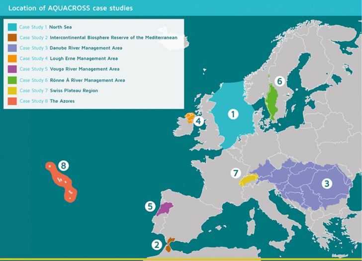
The eight AQUACROSS case studies which can be explored in the new Information Platform. Image: AQUACROSS
Users of the AQUACROSS IP can access datasets from aquatic case studies across Europe, and analyse, visualise and publish the information they contain. At present, there are 580 different datasets available on the platform, many of which were produced through research in eight AQUACROSS case studies.
These case studies are:
- North Sea – trade-offs in ecosystem-based fisheries management to achieve Biodiversity Strategy targets;
- Intercontinental Biosphere Reserve of the Mediterranean, Spain/Morocco – nature-based solutions in transboundary aquatic ecosystems;
- Danube River Basin – harmonising inland, coastal and marine ecosystem management to achieve aquatic biodiversity targets;
- Lough Erne, Ireland – management and impact of Invasive Alien Species;
- Ria de Aveiro Natura 2000 site, Portugal – integrated management of a complex socio-ecological coastal ecosystem;
- Lake Ringsjön and Rönne å Catchment, Sweden – understanding eutrophication processes and restoring good water quality;
- Swiss Plateau – biodiversity management of rivers in densely populated landscapes;
- Azores – ecosystem-based management in a Marine Protected Area with multiple human pressures.

Looking over the Swiss Plateau, one of the AQUACROSS case studies. Image: AQUACROSS
The AQUACROSS IP structure has been designed following guidance from the European INSPIRE Directive, which encourages environmental data sharing and access initiatives. The platform has been developed based on existing open-source CKAN software, following the Open Source Software Strategy and the New Interoperability Framework recommendations from the European Commission.
Juan Arevalo from the IP developing team working at IOC-UNESCO says,
“The development of the AQUACROSS Information Platform is based on CKAN software. This open source framework allowed us to integrate all the requirements from our project stakeholders. I would encourage anyone to use CKAN to develop open data portals given its interoperability with other system and the flexibility for development.”
The AQUACROSS IP is an ongoing, growing project. New resources will be added to the platform in the future, and users are encouraged to contact the managers of the IP with suggestions of relevant datasets which could be linked to the platform. The contact email is – aquacross.IP (at) unesco.org.
More information:
Less than half of European surface waters reach good ecological status, according to new EEA report
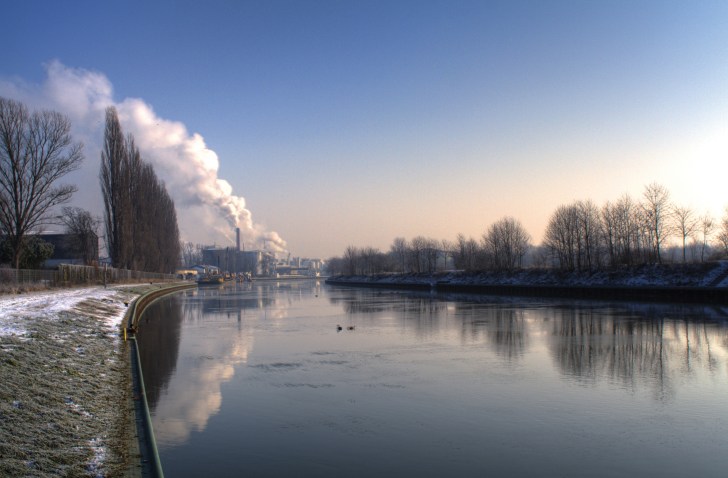
The Neckar River at Ladenburg, Germany, which has significant hydromorphological alterations. Image: EEA
Less than half of Europe’s rivers, lakes and estuarine waters reach good ecological status, according to a recently published European Environment Agency report. Only 40% of European surface water bodies were found to be in a good ecological state, despite significant policy and management initiatives in recent decades to conserve and restore them. Roughly the same percentage (38%) of surface waters reach good chemical status, whilst nearly half (46%) do not.
The EEA report is based on data from EU-member states monitoring their surface and ground waters as part of the Water Framework Directive River Basin Management Plans (RBMPs). The report is the first overall assessment over European waters since 2012, and covers the second round of RBMP reporting. It contains data on over 130,000 water bodies across Europe, which have been monitored over the last six years.
What is ecological status?
Ecological status is an assessment of the structure and function of aquatic ecosystems, and is intended to show the ecological impacts of pressures such as pollution and habitat degradation. It is calculated based on monitoring of biological quality elements (such as fish, insects and plankton), physico-chemical elements (such as nutrient levels, organic pollutants and acidification), and hydromorphological elements (such as water flow, channel shape, and barriers such as dams and weirs). Broadly, then, ‘good’ ecological status means that communities of plants and animals can thrive in aquatic habitats which show minimal impacts of human alterations. ‘Good’ ecological status is the goal for water management under the Water Framework Directive.

Image: EEA 2018
Key pressures on European surface waters
The most significant pressures on surface water bodies were from hydromorphological alterations (such as river straightening, water impoundment and the construction of dams and weirs) and diffuse pollution (particularly of fertilisers from agriculture). Mercury pollution – from atmospheric deposition and urban waste water treatment plants – was a key cause of many water bodies failing to reach good chemical status. The countries with the lowest proportion of water bodies in ‘good’ ecological and chemical status were in heavily-populated and industrialised areas of northern Europe – particularly in south-east England, Netherlands, Belgium and Germany.
Groundwaters in better condition
Groundwaters were generally found to be in better condition across Europe, with 74% of European groundwater areas found to be in good chemical status, and 89% found to be in good quantitative status (i.e. their water stock). Nitrates from agricultural activity and sewage systems were the primary source of groundwater pollution. Water abstraction for public water supplies, agriculture and industry was the key cause of groundwaters failing to achieve good quantitative status.
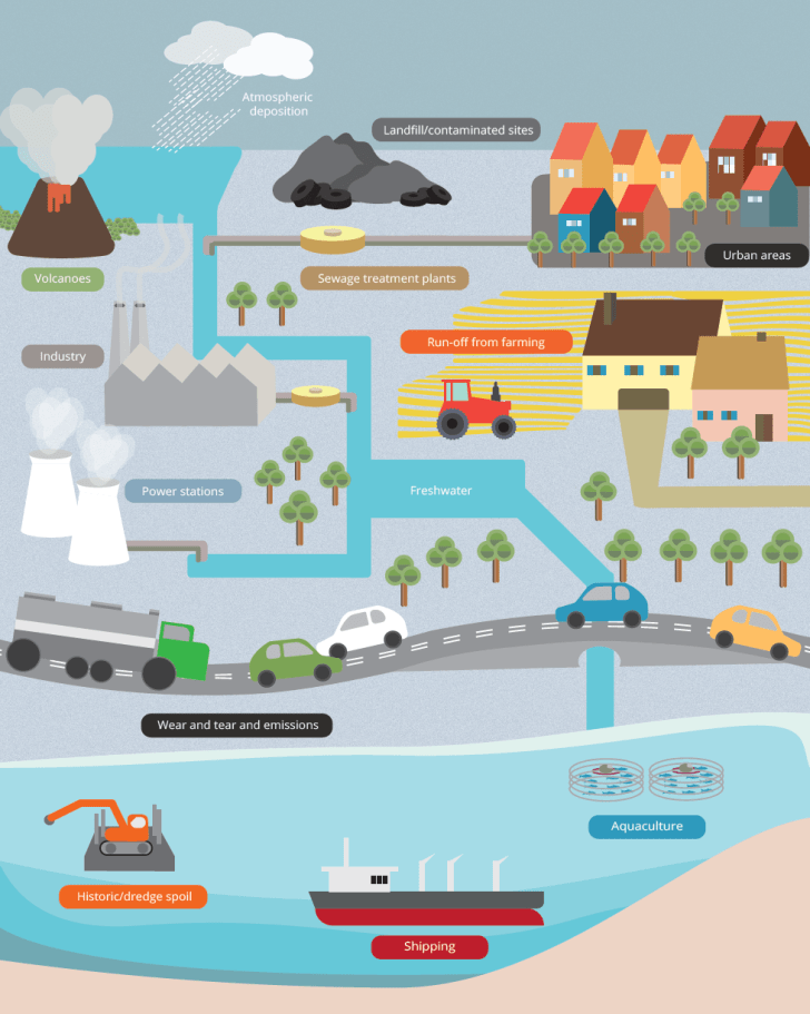
Sources of water pollution across Europe. Image: EEA, 2018
Reflecting on the second River Basin Management Plan reports
It is difficult to properly compare the results of the first and second RBMPs, as European water monitoring programs have been expanded and improved over their period of implementation. But, whilst these monitoring improvements have given scientists and managers a better picture of the stressors and pressures affecting European waters, there appears a long way still to go in successfully mitigating their harmful effects.
“Thanks to the implementation of European water legislation in the Member States, the quality of Europe’s freshwater is gradually improving, but much more needs to be done before all lakes, rivers, coastal waters and groundwater bodies are in good status. Tackling pollution from agriculture, industry and households requires joint efforts from all water users throughout Europe,” says Karmenu Vella, EU Commissioner for Environment, Maritime Affairs and Fisheries.
The report states that most European member states have made significant efforts to improve water quality and reduce hydromorphological pressures on their surface waters. The original intention of the Water Framework Directive – implemented in 2000 – was that all member states should achieve good status in their surface and ground waters by 2015. This has obviously not been achieved, despite the coordinated efforts of policy makers, water managers and scientists across Europe under the WFD.
It is increasingly evident, however, that the ecological impacts of aquatic restoration measures can take a number of years to be realized, especially in complex multiple stress environments. The authors of the EEA report optimistically suggest that by the time the third RBMPs (taking place 2019-2021) are reported upon, the conservation and restoration measures implemented in the first two rounds will have caused significant positive progress towards good ecological status in water bodies across Europe.
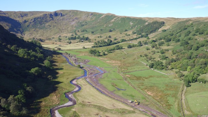
‘Making room for the river’ on the Swindale Beck restoration project in the English Lake District. Image: Lee Schofield | RESTORE Project
The promise of integrated water management
The report calls for an increased focus on integrated water management as a means strengthening WFD implementation and impacts. Its authors highlight three areas in which this could be achieved. First, they advocate the use of management concepts such as the ecosystem services approach and ecosystem-based management as a means of co-ordinating efforts across related EU policies on the marine environment and terrestrial biodiversity. Second, they highlight the potentials of ecological management which works with dynamic natural processes, such as river and floodplan restoration through ‘Room for the River’ type schemes.
Finally, they call for better co-operation between water authorities and other sectors such as agriculture, transport and energy. They highlight Europe 2020 – the EU’s strategy for the growth of a ‘greener’, more environmental economy – as a framework for fostering sustainable water management across sectors.
“We must increase efforts to ensure our waters are as clean and resilient as they should be — our own well-being and the health of our vital water and marine ecosystems depend on it. This is critical to the long-term sustainability of our waters and in meeting our long-term goals of living well within the limits of our planet,” says Hans Bruyninckx, EEA Executive Director.

Clear waters in the Čunovo Dam on the Danube River in Slovakia. Image: Miroslav Petrasko | Flickr Creative Commons
Rivers across the world support rich biodiversity, yet are some of the most threatened global ecosystems, as a result of multiple pressures including pollution, water abstraction, habitat alteration and dam construction. As a result, river conservation and restoration are key topics for scientists, environmental managers and policy makers globally.
A new book Riverine Ecosystem Management: Science for Governing Towards a Sustainable Future provides a cutting-edge overview of contemporary approaches to river management. Available as a free PDF and ePub download, the book is edited by Stefan Schmutz and Jan Sendzimir from BOKU – University of Natural Resources and Life Sciences at the Institute of Hydrobiology and Aquatic Ecosystem Management in Vienna.
Key themes in river management
The book is split into four sections. The first gives an overview of some of the key themes in current river management, namely human impacts, mitigation and restoration. Historical human river uses and impacts are surveyed alongside a series of contemporary river pressures, including alterations to river morphology and hydrology, dam construction and hydropeaking, sediment dynamics, habitat fragmentation, nutrient pollution and recreational fisheries.
The section encompasses emerging threats to river health and status, particularly in chapters by Florian Pletterbauer and colleagues on climate change, and by Ralf B. Schäfer and Mirco Bundschuh on chemical pollution.
Diverse woody habitat on the Lafnitz River in Austria. Image: Graf & Schmidt-Kloiber
Approaches in contemporary river management
The next section provides examples of contemporary approaches for river management and governance. Again, the focus is extremely timely, covering relevant legislative frameworks, integrated river basin management, adaptive management and transboundary water resource management, alongside methodologies for sampling and archiving biological data, such as in Astrid Schmidt-Kloiber and Aaike De Wever’s chapter on Biodiversity and Freshwater Information Systems. Schmidt-Kloiber and De Wever outline the value of online networks for freshwater data such as the Freshwater Information Platform.
A theme that runs through the book is that river ecosystems should be understood (and managed) as integrated ‘social-ecological systems’ in which nature and culture interact. As a result, this second section provides guidance and resources on identifying ecosystem services in river basins, and in fostering public and Non-Governmental Organisation (NGO) engagement and education in river management. Chapters on this theme are written by Kerstin Böck, Michaela Poppe, Christoph Litschauer and colleagues.

Sunset on the urban Danube River in Vienna. Image: Carola Moon | Flickr Creative Commons
Case studies of river management
The third section provides five case studies of river basin management, which illustrate and tie together many of the themes outlined in the previous sections. Three aspects of water management – hydropower, floodplain dynamics and uses, and sturgeon populations – on the Danube River in Central and Eastern Europe are described. These three case studies – written by Herwig Waidbacher, Stefan Preiner, Thomas Friedrich and colleagues – give an indication of the many challenges associated with the environmental management of a large, transboundary river with diverse habitats and competing human interests.
In Burkina Faso in West Africa, Andreas Melcher and colleagues discuss the need for co-ordination of fisheries management at national and local scales, supported by ecological monitoring programs, as a means of supporting sustainable fisheries for local communities. Finally, on the lowland Tisza River in Eastern Europe, Béla Borsos and Jan Sendzimir outline the steps needed to develop an integrated land development (or ILD) management approach in a complex and dynamic river basin.

The frozen Tisza River at Szeged, Hungary. Image: Zoltán Bagi | Flickr Creative Commons
Adaptive and interdisciplinary approaches to managing river systems
In the fourth and final section, the editors draw the book together, emphasising the need for river management to understand the ways in which social and environment systems link and interact in river basins. They highlight the possibilities of new ecological monitoring techniques as well as data management and mining techniques to inform river management, but underline the need for management to be adaptive to an increasingly complex and uncertain world.
Co-editor Stefan Schmutz says, “Despite a rich history of publications on riverine ecosystem management, this book is the first to concisely convey to a broad audience of students, academics and practitioners the frontiers of science and policy for sustainably restoring and managing rivers.”
Co-editor Jan Sendzimir continues, “Unprecedented uncertainty from global change requires an approach that integrates riverine ecosystem understanding and management requirements and options within an interdisciplinary framework. This book applies such a framework to show through a number of case studies how ecosystem and management theories and applications can be successfully used to re-establish and sustain the functional vitality of riverine ecosystems.”

The Open-Access e-book
Arranged as a series of short, accessible chapters, and richly illustrated with colour photographs and diagrams, Riverine Ecosystem Management: Science for Governing Towards a Sustainable Future is likely to prove useful for water managers, academics, students, policy makers and NGOs. Its clear style makes it open to interested non-specialists, too. The e-book also helps communicate a variety of research findings from EU- funded projects, including AQUACROSS, MARS and BioFresh.
There is clearly demand for such a publication – so far the e-book has been downloaded over 53,000 times in two months. For anyone seeking to understand the key debates, approaches and directions in contemporary river management, this is an invaluable resource.
Reporting from MARS: multiple stressor science and management in European aquatic ecosystems

MARS has investigated how multiple stressors affect European rivers, lakes and groundwaters over the last four years. Image: Symbolique 2006
After four years of research on multiple stressor interactions and impacts in European aquatic ecosystems, the EU FP7 MARS project has published its final project report (pdf).
The project began in 2014, and investigated how the complex ‘cocktails’ of stressors such as water pollution, habitat loss and climate change affected ecological status and ecosystem services in rivers, lakes and groundwaters across Europe.
The focus of the MARS project was tailored to support water managers and policy makers, in particular through advising the implementation and 2019 update of the Water Framework Directive and the Blueprint to Safeguard Europe’s Water Resources.
The final MARS report gives a breakdown of project activities and results over the last four years. Significantly, it shows that the project has resulted in over 230 scientific publications, numerous policy briefs and factsheets, and a suite of online tools for water management. This blog post gives a brief overview of some of the research highlights, and more detailed information can be found in the project report.
The IGB LakeLab in Lake Stechlin, Germany – a ‘floating laboratory’ for MARS experiments. Image: HTW Dresden-Oczipka
Multiple Stressor Research and Management
An initial MARS literature review of 219 existing journal articles on multiple stressors found that nutrient stress was involved in most (71–98%) of multiple stress interactions in rivers, lakes and estuary (or ‘transitional’) waters, and just under half (42%) of those in groundwaters. Their impacts were different depending on habitat type, mostly as a result of different hydromorphological (i.e. the water body banks and bed) characteristics and alterations. As a result, nutrient enrichment and hydromorphological alteration was the most common stressor pair overall, particularly in rivers and transitional waters.
MARS research was carried out at three different scales. At the water body scale, experiments with mesocosms and river flumes were used to investigate stressor interactions, and their impacts on ecological status and ecosystem services. At the catchment scale, modelling and empirical approaches were used to characterise the relationships between multiple stressors and ecological responses, functions and services, across 16 European river basins.
Finally, at the European scale, large-scale spatial analyses were carried out to identify relationships between stressor intensity, ecological status and service provision for large transboundary rivers and lakes. This research produced a series of European multi-pressure maps, with threshold values for four important pressure types, and a Stressor Analysis Tool for water managers.

The HyTEC field station in the Austrian Alps – the site of MARS stream experiments. Image: Christian Feld
Key messages from MARS
Around one-third of the 156 MARS case studies across Europe showed significant multiple-stressor effects. As a result, it can be confidently stated that multiple stressors are an important contemporary topic for aquatic science and management. However, a key message from MARS research is that there are rarely predictable relationships between stressor causes and biological effects, and that the characteristics of the local environment can mask or interfere with observed stressor effects.
As a result, it is necessary to investigate and manage the multiple stressor interactions and impacts for individual water bodies and river basins depending on their local biological and geographical characteristics. These can be assessed, diagnosed and managed using a suite of MARS online tools.
In short, what is required is aquatic science research that investigates the direct causes of deteriorated ecological status in rivers and lakes across Europe, a task which can be aided by advances in multiple stressor data collection and diagnostics. This is a key focus for managing and restoring complex aquatic environments under multiple pressures, both now and in the future.

The MARS online tools hosted on the Freshwater Information Platform.
Multiple Stressor Tools
MARS project findings have been integrated into practical and accessible online tools to support water management.
They include:
- Freshwater Information System – including an information library and factsheets on multiple stressors, ecosystem services, case studies and storylines for future environmental scenarios, alongside a model selection tool and guidelines for river basin management;
- Diagnostic Tool for Water Bodies – designed to help water managers diagnose and mitigate multiple stress impacts on rivers and lakes;
- Model Selection Tool – an overview of 21 available computer modelling tools for river basin management;
- Scenario Analysis Tool – allows users to visualise and map multiple stressor interactions and impacts (both present and projected) at the European scale;
- Bayesian Belief Models – designed to help predict biological responses to aquatic conservation and restoration measures under projected future environmental scenarios (see approach here).

Visualisation of an additive pair of stressors – riparian vegetation alteration and phosphate levels – and how they might be managed towards good ecological status, as shown by the diagonal threshold line.
One innovative MARS output for water managers is the visualisation of how stressor-pairs can be managed towards good ecological status. Individual stressors are shown on the x and y axes of the ‘heat map’ diagrams, which are generated by computer modelling, and show a threshold line across which multiple stressor levels should be reduced in order to achieve good ecological status.
Summing up
Reflecting on the last four years, MARS project co-ordinator Sebastian Birk says,
“MARS was a fascinating project, joining the forces of highly skilled scientists across Europe towards unraveling the multi-stressor maze. I feel very honoured for this chance of coordinating such a great team. Most project partners knew each other since the early days of the Water Framework Directive, and this long-standing confidence and trust in each other made this project a delight. Daniel and me would like to express our sincere thanks to all MARS colleagues for this memorable experience! With posting the final project report, this will be kind of the last ‘official’ MARS blog entry. However, there is much more on MARS and beyond, so stay tuned to this channel.”
Read the MARS Final Report (pdf)
Read the ‘Messages from MARS’ blog post
Explore the MARS website

Restored river section five years after restoration with riparian vegetation consisting of grasses, shrubs and trees. Photo: Christian K. Feld
Safeguarding the banks and margins of streams and rivers has a key role to play in ensuring river health. This is the major conclusion from a new international study recently published in Water Research.
The authors of the new study synthesised the findings of more than 100 river management studies, many of which addressed the effects of riparian restoration on riverine habitat and biological conditions. It is widely acknowledged that riparian plants provide food for aquatic organisms, and can mitigate water temperature increases under climate change. Riparian zones can also provide valuable ‘buffer zones’ for run-off from farming and urban areas, preventing pollutants from reaching the river channel. Yet such riparian effects are not to be taken for granted.
Rivers are increasingly threatened by pollution, habitat modification and over-exploitation. Based on the results of the first Water Framework River Basin Management cycle, in 2012 the European Environment Agency (EEA) concluded that more than half of the European river network is damaged by severe human alterations. This picture appears even worse when individual country’s results are considered.
Riparian vegetation is often degraded to a one-row tree line. This may provide shade during summer, yet fundamental functions of riparian vegetation such as nutrient and fine sediment retention cannot be fulfilled. Photo: Christian K. Feld
River restoration approaches generally seek to improve river health, but often struggle with the identification of suitable management options. The team of researchers behind the new study addressed this need during the EU MARS project by reviewing available scientific literature. The scientists analysed the ecological role of riparian vegetation types as well as their configuration and spatial extent. Riparian features were then related to the level of restoration success observed in individual studies.
These results can then be applied to help guide future river restoration activities. Restoration success was evaluated through measures such as the efficiency of nutrients and sediments retention or water temperature ‘dampening’ as a result of riparian vegetation. Over a longer term, the effects that riparian vegetation had on riverine plants and animals could be evaluated.

Benthic invertebrate (caddisfly larvae) that feeds on leaves from riparian shrubs and trees. Photo: Aquatic Ecology, University of Duisburg-Essen
Based on the reviewed literature, the study found that woody riparian vegetation had consistent effects on the supply of leaf-litter and large wood to rivers. Leaves are a fundamental food source for riverine insects in upland rivers, where primary production is strongly limited, and where the food web of aquatic organisms relies on the input of terrestrial carbon.
Woody debris – such as fallen trees, tree trunks, branches and twigs – often increases habitat quality and variety in rivers. Besides the input of organic material, bankside vegetation also provides shade and can effectively ‘dampen’ water warming in spring and summer.
However, despite the observed positive effects of riparian vegetation, this review article also revealed weak and inconsistent effects on the biological quality and diversity of river organisms after riparian restoration. Unfortunately, the reasons behind this finding remained unclear, given that just a small fraction of the reviewed studies included biological effects at all.

Large woody debris in the restored Lippe River in Germany. Image: Benjamin Kupilas | REFORM
Leader of the study, Dr. Christian Feld said, “Land management such as farming or forestry are essential for society – but can damage rivers downstream. We therefore need ways to reduce their unwanted effects, and management of the riparian zone has long been proposed as a cost-effective and local solution. Our evidence shows that riparian restoration can be effective in offsetting some problems, but not all. Larger-scale problems such as pollution from agricultural chemicals or sediments will need larger-scale solutions applied through improvements in the management of whole river catchments.”
Feld highlights the unclear effects of riparian restorations in the retention of nutrients and sediments originating from farmland on the floodplain. The study showed that only riparian plantations that combined trees, shrubs and grasses could effectively reduce nutrient and sediment pollution. However, even then, riparian restorations had only a limited effect where the catchment further upstream was intensively used by agriculture. In contrast, positive effects were more pronounced if riparian restorations took place in the upper parts of the catchment, where the aquatic environment is stronger linked to the riparian conditions.
Professor Steve Ormerod – Co-Director of Cardiff University’s Water Research Institute and co-author of the study – added, “This whole issue is one that needs more holistic ecosystem management. Fresh water is a crucial human resource that needs care, maintenance and sometimes very expensive treatment before it can be supplied to people. Freshwater ecosystems are also losing biological diversity at an alarming rate globally because they are not well protected. We need to step up efforts to balance productive land use against these downstream costs – and our work shows that this needs a blend of local riparian solutions as well as improved large-scale thinking.”

Overview of a restored river section five years after restoration. This riparian zone can effectively buffer the river system from adverse land use impacts on the floodplain, while the shade and organic material provided by the vegetation can promote the instream biology. Photo: Viktoria Berger.
~
The work was funded by the EU MARS project under project No.: 603378
Does water management pay off? Introducing the DESSIN Ecosystem Services Approach framework
The Emscher River in Nordsternpark, a former mining site in Gelsenkirchen, Germany. Image: M. Knuth | Flickr Creative Commons
Two new studies on the potential of the ecosystem services approach in strengthening European water management have been published in the Ecosystem Services journal. Both studies were supported by the EU-funded DESSIN project.
The first study provides a practical guide for water managers to assess changes in ecosystem services as a result of different water management measures. Lead author Gerardo Anzaldúa and colleagues outline that innovative solutions to water quality and quantity problems – such as groundwater replenishment and combined sewage treatments – are continually advancing and improving. However, they argue that existing impact assessment methodologies for investigating their impacts are increasingly limited. An ecosystem services approach can help both the assessment and communication of the impacts and benefits of new water management approaches on human lives, the authors argue.
Anzaldúa and colleagues found that whilst there are already ecosystem services (or ESS) assessment frameworks available to help environmental decision-makers and managers, many existing approaches do not adequately link ecosystem changes to ecosystem service provision. In addition, these assessment frameworks are often data intensive, focus on single issues (such as water scarcity) or service types (such as provisioning services), and – importantly – don’t easily link to Water Framework Directive assessments (although, see the 2015 MARS ‘cookbook’ approach to assessment and valuation)
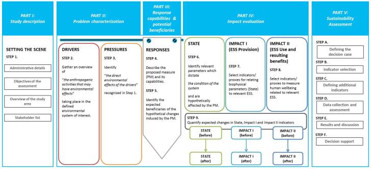
The DESSIN Ecosystem Service Evaluation Framework – structured guidance for ecosystem service assessment. Image: Anzaldua et al. (2018)
The new DESSIN Ecosystem Services Approach framework outlined in their paper aims to address these gaps and shortfalls. The framework is designed to allow users to evaluate and account for the ecosystem service impacts of new and innovative water management approaches. It is intended to complement the implementation of Water Framework Directive River Basin Management, and incorporates a similar DPSIR approach to adaptive management.
The framework is designed to support local-scale evaluations of ecosystem service provision, which are intended to help make assessments more accessible and useful for both stakeholders and decision-makers, and can be scaled-up to river basin and national scales. You can read the full details of the framework in the open-access study here.
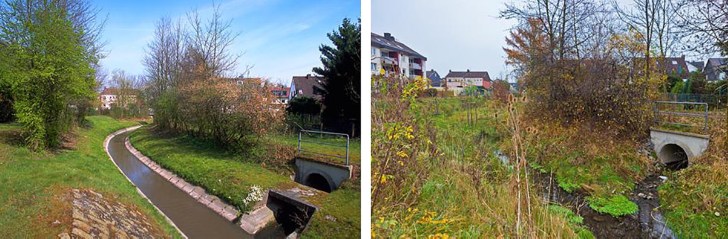
An unrestored (left) and a restored section (right) in Dortmund Aplerbeck in the Emscher catchment. Image: Emschergenossenschaft.
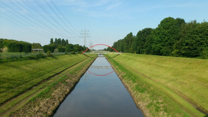
The second paper provides a case study of the DESSIN Ecosystem Services Approach framework in use relating the to the restoration of the Emscher River in Germany. Restoration management to improve the ecological health and status has intensified on the Emscher in recent years, in an effort to reverse decades of water pollution, habitat loss and riverbank alteration.
To assess the values of restoration efforts, Nadine Gerner and colleagues applied the new DESSIN framework to evaluate the provision of regulating (self-purification of water, nursery populations and habitats and natural flood protection) and cultural ecosystem services (aesthetic, recreational and educational values) along stretches of the Emscher.
The research team used economic assessment methods including damage costs avoided, contingent valuation and benefit transfer. They estimated that restoration efforts on the Emscher generated a direct economic impact or market value of over €21 million per year. Market value here means the direct economic benefits to local communities and businesses, such as increased house prices or recreational opportunities.
In addition, they calculated that the non-market value of restoration exceeded €109 million per year. Non-market values includes both willingness to pay and avoided cost calculations and include benefits such as reductions in flooding risk . You can read the full step-by-step application of the DESSIN framework to the Emscher case-study, and the methods and justifications of value calculation in the open-access study here.
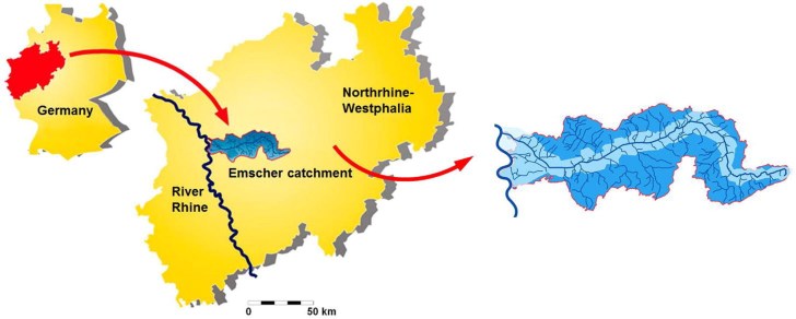
Map of the Emscher catchment in Germany. Image: DESSIN
Gerardo Anzaldúa from the Ecologic Institute in Berlin says, “The attractiveness of the Ecosystem Services Approach resides in its potential to enable individuals with diverse backgrounds and interests to communicate in terms of the inherent value they see in nature. This does not refer only to the monetary worth of ecosystems and their outputs, but to the variety of benefits that humans in direct or indirect contact with them perceive. Unfortunately, this wide-ranging character of the approach is at the same time what has made it so elusive to put into practice, as different disciplines have their own set of rules to understand and solve problems.”
“In DESSIN we had the chance to bring together a core group of ecologists, economists, engineers and sociologists under a single common goal: developing a way to run locally relevant and practicable ESS evaluations,” Anzaldúa explains.
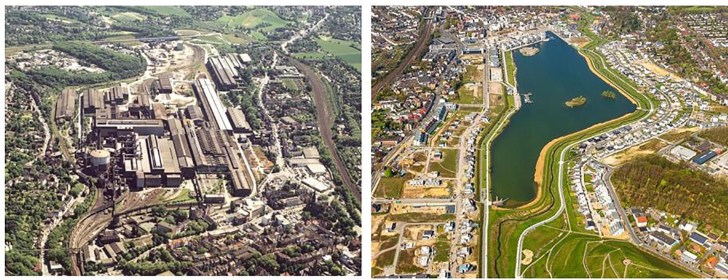
Before (left) and after (right) construction of Lake Phoenix and restoration of the Emscher in Dortmund. Image: City of Dortmund / Emschergenossenschaft.
Nadine Gerner from Emschergenossenschaft continues, “In this way, the DESSIN ESS Evaluation Framework was developed on the basis of three case studies where restoration projects and innovative solutions had already been implemented in the past. Therefore, it was possible to compare the status before and after the solutions were implemented. The case studies were distributed throughout Europe in order to cover a broad geographical range with diverse environmental conditions and social dimensions as well as a wide variety of ESS types.”
“Ongoing restoration measures as part of the reconversion of the Emscher River in Germany were evaluated with regard to their impact on ESS provision, use and benefit. Regulation and Maintenance ESS – such as the self-purification capacity, maintaining nursery populations and habitats and flood protection – were evaluated, as well as Cultural ESS describing aesthetic, recreational, educational and existence values.” Gerner says.
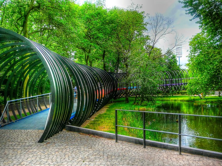
An art installation by Tobias Rehberger at Emscherkunst, an exhibition of contemporary environmental art along the banks of the Emscher. The river basin is increasingly a space for recreation and tourism. Image: Reinhard H | Flickr Creative Commons
Read the new open-access papers in full here:


